Paper Harvest Report
Date range: May 06, 2026
5 top-tier papers selected out of 134 total publications
Today’s Highlights
Deforestation combined with just 1.5–1.9°C of global warming could trigger a near system-wide transition of the Amazon forest, with cascading drought effects spanning thousands of kilometres (Nature). A massive landslide-tsunami in an Alaska fjord — preconditioned by glacial retreat — produced a 481-meter runup, underscoring escalating coastal hazards from climate change (Science). Meanwhile, SWOT satellite observations reveal systematic snow/ice penetration biases in glacial lake water level measurements, and new work quantifies how urea runoff fuels eutrophication in agricultural surface waters.
Table of Contents
- Today’s Highlights
- Top-Tier Journal Papers
- Deforestation-induced drying lowers Amazon climate threshold
- Towards disentangling human-induced drivers of precipitation trends from naturally occurring ones
- A 481-meter-high landslide-tsunami in a cruise ship–frequented Alaska fjord
- A First Look at the Snow/Ice Penetration Effect of SWOT Observations on Water Level of Global Glacial Lakes
- Urea runoff fuels eutrophication of shallow surface waters in agricultural regions
- Statistics
- Filtering Criteria
Top-Tier Journal Papers
Deforestation-induced drying lowers Amazon climate threshold
Authors: Nico Wunderling, Boris Sakschewski, Johan Rockström, Bernardo M. Flores, Marina Hirota et al.
Journal: Nature · DOI: 10.1038/s41586-026-10456-0
Matched topics: drought
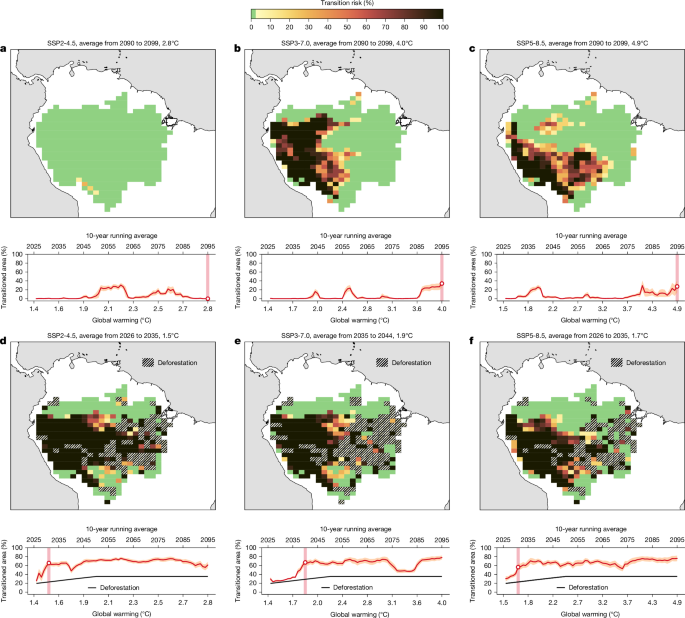
Humanity is putting unprecedented pressures on the Amazon forest system through global warming and land use changes. As the Amazon forest may undergo self-reinforcing transitions, these pressures could lead to system-wide changes across major parts of Amazonian ecosystems. Here we apply a dynamical systems model to assess the local and far-reaching cascading transition risks towards degraded ecosystems in the Amazon biome under different Shared Socioeconomic Pathways. For these emission scenarios, we constructed how moisture is transported through the atmosphere within the Amazon basin using an established atmospheric moisture-tracking model. Without accounting for deforestation, we find a critical global warming threshold of 3.7–4.0 °C, beyond which up to a third of the Amazon forest risks losing stability. However, when considering deforestation, we find a near system-wide transition of the Amazon forest (62−77% of the area) under the combination of a lower threshold range of global warming of 1.5–1.9 °C and deforestation of 22–28%. The large majority of the simulated transitions is caused by spatial knock-on effects from increasing drought intensities, leading to long-ranging and self-propelling cascades on scales of hundreds to thousands of kilometres. Overall, our results reinforce the need to keep global warming levels below 1.5 °C and halt deforestation, as well as ecologically restore degraded forests to avoid high transition risks across the Amazon forest system.
Towards disentangling human-induced drivers of precipitation trends from naturally occurring ones
Authors: —
Journal: Nature · DOI: 10.1038/d41586-026-01419-6
Matched topics: precipitation, climate models

Combining climate models with statistical learning allows an assessment of the relative contributions of different factors to trends in winter precipitation at mid-latitudes. Thermodynamic (non-circulation-related) effects are mostly consistent between models and observations, but whether circulation-related changes are forced or unforced remains unclear. An analysis of climate models reveals the roles of internal variability and forced-circulation-induced precipitation trends.
A 481-meter-high landslide-tsunami in a cruise ship–frequented Alaska fjord
Authors: Dan H. Shugar, Katherine R. Barnhart, Mira Berdahl, Jacqueline Caplan-Auerbach, Göran Ekström et al.
Journal: Science · DOI: 10.1126/science.aec3187
Matched topics: climate change, coastal

Early in the morning of 10 August 2025, a >64 × 10⁶ m³ landslide struck Tracy Arm fjord in Alaska. The landslide was preconditioned by glacial retreat caused by climate change. The resulting 481 m runup megatsunami followed an initial 100-m-high breaking wave traveling >70 m s⁻¹. The landslide was preceded by several days of microseismicity, which increased in rate and magnitude until ~1 hour before failure. The landslide produced globally observed long-period seismic waves equivalent in size to a M5.4 earthquake. A long-period (~66 s) global seismic signal, produced by a landslide-induced seiche trapped within the fjord, persisted for up to 36 hours, the second time a days-long seiche has been thus observed. With fjord regions increasingly visited by cruise ships, and climate change making similar events more likely, this unanticipated, near-miss event highlights the growing risk from landslides and tsunamis in coastal environments.
A First Look at the Snow/Ice Penetration Effect of SWOT Observations on Water Level of Global Glacial Lakes
Authors: Shuangxiao Luo, Chunqiao Song, Pengfei Zhan, Jiayi Li, Li Peng
Journal: Geophysical Research Letters · DOI: 10.1029/2026gl122624
Matched topics: surface water

The Surface Water and Ocean Topography (SWOT) mission promises quasi-global monitoring of glacial lakes, yet the elevation difference arising from its Ka-band radar penetrating lake snow/ice cover remains unquantified. This poses a challenge to assessing their level changes. We present the first quantification of this difference by intercomparing SWOT and ICESat-2 surface elevations over 260 glacial lakes (>1 km²) globally. Given ICESat-2’s laser measures the snow/ice surface, we leverage near-synchronous observations to treat the elevation difference as an empirical measure of the snow/ice penetration effect of SWOT. We find a globally consistent negative difference (SWOT minus ICESat-2) of −0.25 m over the 1-year period. This difference is dependent on season, amplifying by more than double from −0.15 m (warm) to −0.34 m (cold), with peak monthly differences nearly reaching −1 m. This study provides a framework for reconciling SWOT and ICESat-2 observations, enabling long-term, high-resolution records of glacial lake variability.
Urea runoff fuels eutrophication of shallow surface waters in agricultural regions
Authors: Daniel J. Conley
Journal: Nature Water · DOI: 10.1038/s44221-026-00641-w
Matched topics: runoff, surface water

Abstract not available.
Statistics
| Metric | Count |
|---|---|
| Journals searched | 11 |
| Total papers fetched | 134 |
| Passed deterministic filter | 9 |
| After LLM relevance filtering | 5 |
| Rejected (not relevant) | 4 |
Papers by journal
| Journal | Papers |
|---|---|
| Nature | 2 |
| Science | 1 |
| Geophysical Research Letters | 1 |
| Nature Water | 1 |
Filtering Criteria
Topics: hydrology, hydrologic model, river, runoff, streamflow, reservoir, water management, flood, drought, seasonal, land surface model, climate change, hydropower, surface water, irrigation, earth system model, estuary, coastal, freshwater discharge, river plume, ocean biogeochemistry, marine heatwave, paleohydrology, paleoclimate, Quaternary, Holocene, Pleistocene, fluvial geomorphology, river terrace, loess, drainage network, river capture, landscape evolution, luminescence dating
Fields: engineering, environmental science, computer science, geology, geography