Paper Harvest Report
Date range: June 04, 2026
3 top-tier papers selected out of 11 total publications
Today’s Highlights
SWOT satellite data enabled the first systematic characterization of seasonal hydrodynamics across global lake-river transitions, revealing how reservoir regulation drives distinct backwater and drawdown regimes along river-to-reservoir corridors. Simultaneously, a Nature Communications study demonstrates that human-induced shifts in Northern Hemisphere westerly winds are fundamentally reorganizing terrestrial gross primary productivity at hemispheric scales—greenhouse gas forcing is the dominant driver, with projected impacts diverging sharply between northern regions (enhanced) and southern Europe/central North America (suppressed). A high-resolution global satellite analysis of tree cover loss rounds out the harvest, quantifying land-use conversion pathways that reshape land surface hydrology worldwide.
Table of Contents
Top-Tier Journal Papers
From Lotic to Lentic: SWOT Characterizes Seasonal Hydrodynamics in the Lake‐River Continuum
Authors: Xinchen He, Jida Wang, George H. Allen, Huilin Gao, Bruce Rhoads, Katie McQuillan, Paul D. Bates, Jean-François Crétaux
Journal: Geophysical Research Letters · DOI: 10.1029/2026gl122664
Matched topics: river, reservoir, water management, seasonal, surface water
The interface between rivers and lakes forms a unique hydraulic continuum, in which lotic and lentic regimes dynamically interact and transition between each other. A common expression of this lake‐river continuum (LARIC) is reservoir backwater, where water surface gradually rises from the reservoir pool upstream to the free‐flowing river. Observing this nuanced hydrodynamics is challenging but critical for understanding fluvial‐lacustrine connectivity. Here, we couple open‐channel hydraulic theory with water‐surface profiles derived from Surface Water and Ocean Topography (SWOT) satellite data to characterize the hydrodynamic zone along river‐to‐reservoir transitions. Our prototype framework adaptively delineates LARIC transition zones, classifies regime types (M1 backwater and M2 drawdown), and quantifies their longitudinal and vertical extents. The characterized hydrodynamics agree with theoretical expectations and reveal pronounced seasonal variability in response to reservoir regulations. Together, these results demonstrate SWOT’s unique potential for global LARIC characterization and underscore its value for lake‐river science and water management.
Human-induced westerly jet shifts coordinate terrestrial productivity at the hemispheric scale
Authors: Xiaoye Yang, Aiguo Dai, Gabriele Messori, Bin He, Zhibo Li, Ziqian Zhong et al.
Journal: Nature Communications · DOI: 10.1038/s41467-026-74039-3
Matched topics: river
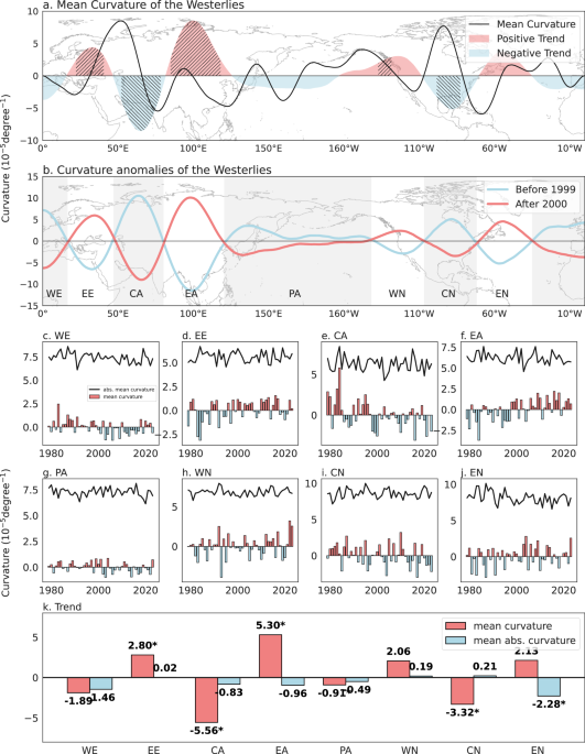
Previous studies have established how regional climate variability regulates local terrestrial gross primary productivity (GPP), yet the hemispheric-scale spatial organization of GPP, coordinated by large-scale atmospheric circulation, remains poorly understood. Here, using multi-source observations and numerical simulations, we show that anthropogenic shifts in Northern Hemisphere westerlies fundamentally reorganize terrestrial GPP patterns. Around 2000, westerly curvature reversed from a southward to a northward bend over eastern Europe, Northeast Asia, and western North America, while exhibiting opposite changes over central Asia and central North America. Spatial patterns of GPP trends during 1982–2018 closely match GPP responses to westerly curvature variations. Sensitivity analyses using CESM1 large-ensemble simulations and single-forcing experiments identify greenhouse gas forcing as the dominant driver of these changes, thereby reshaping GPP through surface climatic factors. Under the RCP8.5 scenario, continued curvature changes are projected to enhance GPP growth across northern Europe, Northeast Asia, and western North America, while suppressing productivity in southern Europe and central North America. These results reveal anthropogenic forcing influences terrestrial carbon uptake via large-scale atmospheric circulation, with important implications for predicting future carbon–climate feedback.
Global extent and drivers of tree cover loss quantified with high-resolution satellite data
Authors: Alexandra Tyukavina, Andrew J. Poulson, Jeffrey Pickering, Bernard Adusei, Matthew C. Hansen, Peter Potapov et al.
Journal: Science · DOI: 10.1126/science.adz9042
Matched topics: river
Quantifying the drivers of tree cover loss globally provides a synoptic understanding of pressures on the world’s forests. Existing information about tree cover loss drivers relies on maps of coarse spatial and thematic resolution. In this study, we quantified the global extent of tree cover loss in 2018 at the scale of individual disturbances and provided a comprehensive accounting of land use outcomes using a global probability sample of 600 5 × 5-kilometer blocks mapped with high-resolution (3- to 10-meter) satellite data. Out of 277 thousand square kilometers of estimated global tree cover loss, nearly a third (29.0%) was due to long-term conversion of tree cover to other land uses, including conversion of natural tree cover to pasture (15.0%), cropland (6.4%), and nontimber tree plantations (3.8%).
Statistics
| Metric | Count |
|---|---|
| Journals searched | 11 |
| Total papers fetched | 113 |
| Passed deterministic filter | 11 |
| After LLM relevance filtering | 3 |
| Rejected (not relevant) | 8 |
| AI for Science items picked | 0 |
Papers by journal
| Journal | Papers |
|---|---|
| Geophysical Research Letters | 1 |
| Nature Communications | 1 |
| Science | 1 |
Filtering Criteria
Topics: hydrology, hydrologic model, river, runoff, streamflow, reservoir, water management, flood, drought, seasonal, land surface model, climate change, hydropower, surface water, irrigation, earth system model, estuary, coastal, freshwater discharge, river plume, ocean biogeochemistry, marine heatwave, paleohydrology, paleoclimate, Quaternary, Holocene, Pleistocene, fluvial geomorphology, river terrace, loess, drainage network, river capture, landscape evolution, luminescence dating
Fields: engineering, environmental science, computer science, geology, geography