Paper Harvest Report
Date range: June 15, 2026
4 top-tier papers selected out of 98 total publications
Today’s Highlights
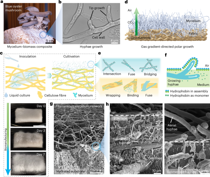
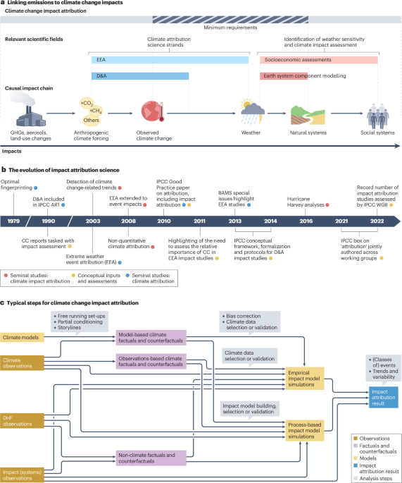
A Galápagos coral record pushes ENSO reconstruction back 4,000 years, finding mid-Holocene La Niña variability stronger than the pre-industrial era but weaker than the last few decades (GRL). In Nature Water, a living mycelium biomulch demonstrates directed atmospheric water capture for soil irrigation — a low-cost route to water in arid agricultural settings. The day’s standout is a Nature Communications deep-learning model that completes spatially-complete 30-m flood hazard maps for the contiguous US, revealing 11 million people and 4.1 million buildings exposed to previously unrecognized risk, with unmapped areas disproportionately falling on elderly and child populations. A Nature Reviews Earth & Environment piece rounds out the day with a survey of approaches and challenges in attributing climate-change impacts.
Table of Contents
- Today’s Highlights
- Top-Tier Journal Papers
- Eastern Pacific Corals Track Robust ENSO Variability and Stronger La Niña Events 4,000 Years Before Present
- Living mycelium biomulch for directed atmospheric water capture and soil irrigation
- Deep learning completes US flood hazard maps revealing millions exposed to previously unrecognized risk
- Approaches, challenges and applications of climate change impact attribution
- AI for Science
- Statistics
- Filtering Criteria
Top-Tier Journal Papers
Eastern Pacific Corals Track Robust ENSO Variability and Stronger La Niña Events 4,000 Years Before Present
Authors: C. J. Tripp, J. E. Cole, A. W. Tudhope, K. A. Dyez, D. M. Thompson, R. L. Edwards
Journal: Geophysical Research Letters · DOI: 10.1029/2025gl119006
Matched topics: Holocene
The interannual El Niño‐Southern Oscillation (ENSO) triggers extreme climate events worldwide. Geochemical proxies in coral skeletons from the eastern equatorial Pacific (EP) track ENSO conditions, constraining its long‐term variance and response to forcing. Multiproxy analysis of three subfossil colonies from the EP Galápagos Islands finds ENSO variability ∼4,000 years before present (BP) was similar to that from 1959 to 1979 CE. These mid‐Holocene results exhibit stronger ENSO variability than that over the preindustrial last millennium, but weaker than that between 1986 and 2016 CE. Whereas positively skewed instrumental and reconstructed temperatures reveal the predominance of warm ENSO events in the modern EP, the corals from 4,000 BP record negatively skewed variance reflecting stronger cold events. The Galápagos results contrast with central equatorial Pacific (CP) coral records identifying minimal ENSO variance from 5,000 to 3,000 BP. Stronger cold events in the EP likely limited CP ENSO variability, creating spatially diverse ENSO signals at 4,000 BP.
Living mycelium biomulch for directed atmospheric water capture and soil irrigation
Authors: Xiaojie Liu, Yanpei Tian, Wenhui Xu, Dylan Boylan, Pengfei Deng, Fengyin Du et al.
Journal: Nature Water · DOI: 10.1038/s44221-026-00664-3
Matched topics: irrigation
Abstract not available.
Deep learning completes US flood hazard maps revealing millions exposed to previously unrecognized risk
Authors: Abraham Noah Wu, Ye Zhang, Rudi Stouffs
Journal: Nature Communications · DOI: 10.1038/s41467-026-74336-x
Matched topics: flood
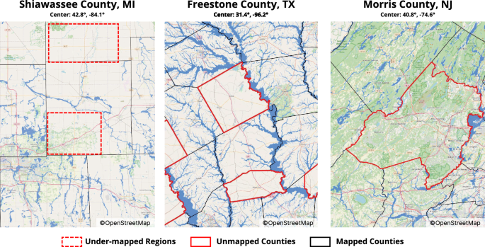
Flood maps are essential for disaster preparedness, insurance and climate adaptation, yet US official maps cover only one-third of river channels. Here we present a deep-learning framework that learns from existing records to produce a spatially complete 30-m flood hazard map for the contiguous US, filling unmapped regions and updating legacy extents. We estimate that the 2023 national database omits 11 million people and 4.1 million buildings in flood zones, adding 69% and 81% beyond the official baseline respectively. Crucially, our socioeconomic analysis of 917 cities reveals that entirely unmapped areas disproportionately harbor highly vulnerable demographics, particularly the elderly and children, exposing them to unrecognized risks and compounding existing inequalities. By solving the trilemma between accuracy, scale, and cost in national scale flood mapping, our open-source method broadens public access to risk information, paving the way for targeted and equitable climate adaptation. Millions in the US lack official flood risk data. This study uses an AI model to learn from existing maps and complete the US flood hazard map, revealing over 11 million more people exposed to flood risks, a 69% increase from current official records.
Approaches, challenges and applications of climate change impact attribution
Authors: Sabine Undorf, Asya Dimitrova, Luke J. Harrington, Gabriele C. Hegerl, Aglaé Jézéquel, Joyce Kimutai et al.
Journal: Nature Reviews Earth & Environment · DOI: 10.1038/s43017-026-00798-8
Matched topics: climate change
Abstract not available.
AI for Science
Cross-discipline sparks
- Elephant alert! AI warning systems aim to avoid deadly clashes (MIT Technology Review, 2026-06-23) — India is rolling out AI-driven sensor networks that predict and flag dangerous human-elephant encounters in real time, in regions where 80% of elephant habitat sits outside protected areas. The underlying recipe — cheap field sensors plus lightweight on-device inference, no institutional-scale infrastructure required — is exactly what a small hydrology team would need to stand up a flash-flood or glacial-lake-outburst early-warning network for an unmonitored watershed, a project class that used to require dedicated forecasting staff and expensive gauge networks.
Statistics
| Metric | Count |
|---|---|
| Journals searched | 11 |
| Total papers fetched | 98 |
| Passed deterministic filter | 14 |
| After LLM relevance filtering | 4 |
| Rejected (not relevant) | 10 |
| AI for Science items picked | 1 |
Papers by journal
| Journal | Papers |
|---|---|
| Geophysical Research Letters | 1 |
| Nature Water | 1 |
| Nature Communications | 1 |
| Nature Reviews Earth & Environment | 1 |
Filtering Criteria
Topics: hydrology, hydrologic model, river, runoff, streamflow, reservoir, water management, flood, drought, seasonal, land surface model, climate change, hydropower, surface water, irrigation, earth system model, estuary, coastal, freshwater discharge, river plume, ocean biogeochemistry, marine heatwave, paleohydrology, paleoclimate, Quaternary, Holocene, Pleistocene, fluvial geomorphology, river terrace, loess, drainage network, river capture, landscape evolution, luminescence dating
Fields: engineering, environmental science, computer science, geology, geography