Paper Harvest Report
Date range: May 20, 2026
4 top-tier papers selected out of 136 total publications
Today’s Highlights
A PNAS study introduces a novel method to reverse-engineer 3D fluvial landscapes from 2D stream networks using hydraulic geometry, with applications to Earth, Mars, and Titan. A new isotope-based precipitation index offers improved tracking of hydroclimatic anomalies and drought events, while cosmogenic nuclide evidence pushes Atacama Desert hyperaridity back to the Eocene — earlier than previously thought.
Table of Contents
- Today’s Highlights
- Top-Tier Journal Papers
- Hydraulic geometry hypothesis allows reverse engineering of 3D quasi-equilibrium landscapes from 2D channel networks: Earth, Mars, Titan
- Drivers of Basal Melt Variability for Pine Island Glacier Ice Shelf: Ocean Forcing Versus Geometric Feedback
- Prediction of Hydroclimatic Anomalies Using a New Isotope Precipitation Index
- Evidence for Eocene aridification of the Atacama Desert’s hyperarid core
- Statistics
- Filtering Criteria
Top-Tier Journal Papers
Hydraulic geometry hypothesis allows reverse engineering of 3D quasi-equilibrium landscapes from 2D channel networks: Earth, Mars, Titan
Authors: Li Zhang, Dnyanesh Borse, Arvind Singh, James E. Pizzuto, Xudong Fu et al.
Journal: Proceedings of the National Academy of Sciences · DOI: 10.1073/pnas.2513733123
Matched topics: river
The 2D dendritic structure of stream networks within fluvial catchments has not previously been linked to reach-scale channel processes. Existing extensions of 2D network models to 3D landscapes yield only pixelized landscapes, without resolving channels or their properties. At-a-point relations for hydraulic geometry alone provide no insight into how fluvial processes sculpt 3D landscapes in which channels are embedded. We provide this insight by reverse-engineering generic fluvial landscapes with scalable dimensions for all attributes. We do this by coupling a) a 2D network generator, b) dimensionless, physically grounded relations for gravel-bed river hydraulic geometry, and c) a simplified hillslope model. Catchment hypsometric curve and relief, as well as relations between local channel properties and basin structure, cannot be predicted with just one of these components. Our model predicts in specific, dimensioned terms not only how attributes such as hypsometric curve change with changing bed grain size, precipitation and catchment area, but also why, because each model element can be interrogated individually or jointly. Our method offers a tool for studying the effect of varied mean annual precipitation and intensity on catchment structure. Our central application is to tectonically inactive, quasi-equilibrium, low-relief montane landscapes on Earth. We underline the insight provided by our formulation through application to analogous planetary fluvial landscapes. We implement this for Mars and Titan using appropriate values for gravitational acceleration and sediment submerged specific gravity, both freely variable in our model. Our reverse-engineering methodology indicates why and how an analogous class of landscapes should differ in different planetary settings.
Drivers of Basal Melt Variability for Pine Island Glacier Ice Shelf: Ocean Forcing Versus Geometric Feedback
Authors: Katie Lowery, Paul R. Holland, Pierre Dutrieux, Anna E. Hogg, Noel Gourmelen
Journal: Geophysical Research Letters · DOI: 10.1029/2025gl121404
Matched topics: river
Since the 1970s, Pine Island Glacier has exhibited thinning, acceleration, and retreat. During the last decade, the ice shelf has undergone major geometric changes, whilst the quantity and temperature of modified Circumpolar Deep Water on the Amundsen Sea continental shelf fluctuated significantly. Untangling how these factors modulate ice‐shelf basal melt rates is critical, as ocean‐driven melt may be mitigated through emission reductions, whereas geometry‐driven retreat may be irreversible. We use ocean model experiments to partition the relative importance of ice geometry and ocean temperature changes in driving melt variability between 2011 and 2021. Simulations use observed ice‐shelf geometries from CryoSat‐2 and ocean boundary conditions from moorings in Pine Island Bay. Temporal variability of melt and implied ice loss during this period was largely controlled by ocean conditions, while geometric evolution primarily controlled the spatial distribution of melt through cavity circulation reconfiguration, with a non‐negligible impact on buttressing.
Prediction of Hydroclimatic Anomalies Using a New Isotope Precipitation Index
Authors: A. Watson, J. Miller, J. de Waal, H. Beckett, Y. Vystavna et al.
Journal: Geophysical Research Letters · DOI: 10.1029/2025gl120780
Matched topics: drought, seasonal
Global warming is driving changes in atmospheric moisture seasonality and an increase in the frequency of prolonged precipitation anomalies. These anomalies are often assumed to be characterized by moisture sourced from oceanic evaporation, rather than being moderated by recycled terrestrial evapotranspiration. However, current indexes used to evaluate hydroclimatic anomalies, which exclude particle tracking, do not account for different precipitation moisture sources. Here, stable isotopes of hydrogen and oxygen are used to differentiate precipitation moisture sources, enabling a novel approach to tracking anomalous dry periods through an isotope‐based Evaporation and Moisture Recycling Index (iEMI). iEMI correlated evaporation‐sourced precipitation with prolonged dry periods for European droughts (2011–2013), the Cape Town South Africa “Day Zero drought” (2015–2018) and the Australian Millennium drought (1997–2010). iEMI aligned best to anomalous precipitation events linked to the strength and phase of the El Niño Southern Oscillation across all sites and could be used for drought management interventions.
Evidence for Eocene aridification of the Atacama Desert’s hyperarid core
Authors: Benedikt Ritter-Prinz, Steven A. Binnie, Finlay M. Stuart, Derek Fabel, Richard Albert et al.
Journal: Nature Communications · DOI: 10.1038/s41467-026-73422-4
Matched topics: river, coastal, landscape evolution
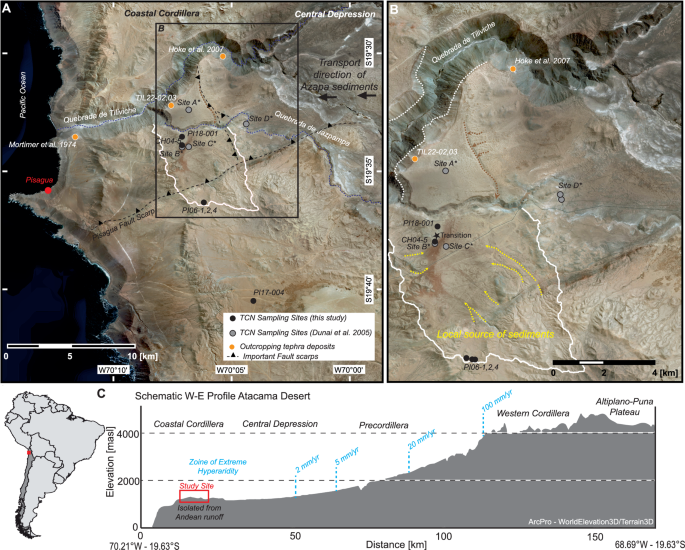
The Atacama Desert is the most arid non-polar region on Earth, yet the timing and drivers of its hyperaridity remain debated. The earliest record of extreme aridification is preserved in the Coastal Cordillera of Northern Chile at the Oligocene-Miocene boundary. However, clast exposure ages on low-relief surfaces and supergene mineralisation ages suggest that low precipitation, and thus limited surface activity and weathering, may have been established earlier. To test the Miocene hyperaridity hypothesis, we have established a record of surface activity based on cosmogenic 21Ne concentrations in 135 locally-derived quartz clasts from low-relief surfaces in the desert’s core. Thirty-two clasts have modelled exposure durations of Oligocene age or older. Their long-term surface preservation suggests exceptionally low landscape evolution rates and implies that aridification initiated earlier than the development of the Humboldt Current and major Andean uplift. We hypothesize that global cooling following the Early Eocene Climatic Optimum was likely a key driver of regional aridification.
Statistics
| Metric | Count |
|---|---|
| Journals searched | 11 |
| Total papers fetched | 136 |
| Passed deterministic filter | 9 |
| After LLM relevance filtering | 4 |
| Rejected (not relevant) | 5 |
| AI for Science items picked | 0 |
Papers by journal
| Journal | Papers |
|---|---|
| Proceedings of the National Academy of Sciences | 1 |
| Geophysical Research Letters | 2 |
| Nature Communications | 1 |
Filtering Criteria
Topics: hydrology, hydrologic model, river, runoff, streamflow, reservoir, water management, flood, drought, seasonal, land surface model, climate change, hydropower, surface water, irrigation, earth system model, estuary, coastal, freshwater discharge, river plume, ocean biogeochemistry, marine heatwave, paleohydrology, paleoclimate, Quaternary, Holocene, Pleistocene, fluvial geomorphology, river terrace, loess, drainage network, river capture, landscape evolution, luminescence dating
Fields: engineering, environmental science, computer science, geology, geography