Paper Harvest Report
Date range: May 19, 2026
9 top-tier papers selected out of 123 total publications
Today’s Highlights
Compounding hazards are the dominant driver of flood economic losses across Europe, with the top 1% of loss events all involving multiple concurrent hazards totaling over €167 billion above single-hazard floods. A new integrated dynamical-statistical model significantly improves subseasonal precipitation prediction in the Yangtze River Basin at 10–40-day leads, outperforming direct ECMWF forecasts. Meanwhile, US tidal wetlands are losing ground at an accelerating rate, with extreme weather now overtaking sea level rise as the primary driver of loss.
Table of Contents
- Today’s Highlights
- Top-Tier Journal Papers
- River oxygen levels are dropping around the world as Earth warms
- Non‐Linear Morphodynamic Response of Deltas to Extreme Events
- Modeling Circulation‐Precipitation Overlapped Co‐Evolution for Improving Subseasonal Prediction in the Yangtze River Basin
- Spring–Summer Caribbean Sea marine heatwaves tied to previous Winter Indian Ocean marine heatwaves
- Local drivers in accelerating North American heat stress
- Compounding hazards increase flood economic losses across Europe
- Addressing global hotspots of drought-related crop production losses
- Role of Earth system processes in the relationship between climate change and cumulative carbon emissions
- The accelerating loss and shifting dynamics of US tidal wetlands
- Statistics
- Filtering Criteria
Top-Tier Journal Papers
River oxygen levels are dropping around the world as Earth warms
Authors: Nature News
Journal: Nature · DOI: 10.1038/d41586-026-01594-6
Matched topics: river

Abstract not available.
Non‐Linear Morphodynamic Response of Deltas to Extreme Events
Authors: O. A. Prasojo, A. Leenman, E. Baynes
Journal: Geophysical Research Letters · DOI: 10.1029/2025gl120954
Matched topics: river, flood, climate change, coastal
Deltas, the interface between riverine and coastal systems, host ∼500 million people and function as crucial ecological nexuses. The magnitude and frequency of extreme floods are projected to intensify as climate changes, yet the potential impacts on delta morphodynamics remain poorly understood. Using the pyDeltaRCM numerical model, we explore the impact of extreme flow frequency on delta morphology. Morphometric analyses demonstrate a non‐linear morphodynamic response across two orders of magnitude of extreme flow intermittencies, I. Under medium I, deltas are smallest with the fewest, narrowest channels. In contrast, at both low and high I, deltas grow the largest, with the widest and most numerous channels. Channel mobility appears unaffected and delta slope declines monotonically as I increases. We identify drivers of this non‐linear response, generating a novel conceptual model of delta adjustment to extreme flows. Our morphodynamic projections can help anticipate and manage geomorphic change on deltas undergoing flood‐frequency change.
Modeling Circulation‐Precipitation Overlapped Co‐Evolution for Improving Subseasonal Prediction in the Yangtze River Basin
Authors: Fang Zhou, Hong‐Li Ren, Li Gao, Yiwei Li, Lin Wang et al.
Journal: Geophysical Research Letters · DOI: 10.1029/2026gl122773
Matched topics: river, flood, seasonal
Severe precipitation in the Yangtze River Basin (YRB) poses escalating flood risks, underscoring urgent needs for skillful subseasonal prediction. In this study, we develop an integrated dynamical‐statistical downscaling model based on overlapping circulation‐precipitation co‐evolution (OCPCE), which merges prior and concurrent circulation evolution to predict rainfall anomalies. The core innovation shifts from conventional downscaling of dynamical model‐predicted circulation to an integrated framework combining observed recent evolution with highly predictable portions of future circulation from dynamical subseasonal‐to‐seasonal (S2S) models within an optimal overlapping time window. Implemented via evolution‐based singular value decomposition, this design maximizes retention of useful initial information while suppressing lower‐skill long‐lead predictions. The OCPCE model demonstrates statistically significant deterministic skill over YRB and reliable probabilistic predictions at 10–40‐day leads, substantially outperforming direct ECMWF‐S2S predictions. This work offers a physically coherent and operationally viable framework for improving subseasonal precipitation prediction, providing critical support for early flood warning and proactive disaster prevention.
Spring–Summer Caribbean Sea marine heatwaves tied to previous Winter Indian Ocean marine heatwaves
Authors: Zeyu Li, Jianping Li
Journal: Nature Communications · DOI: 10.1038/s41467-026-73130-z
Matched topics: marine heatwave
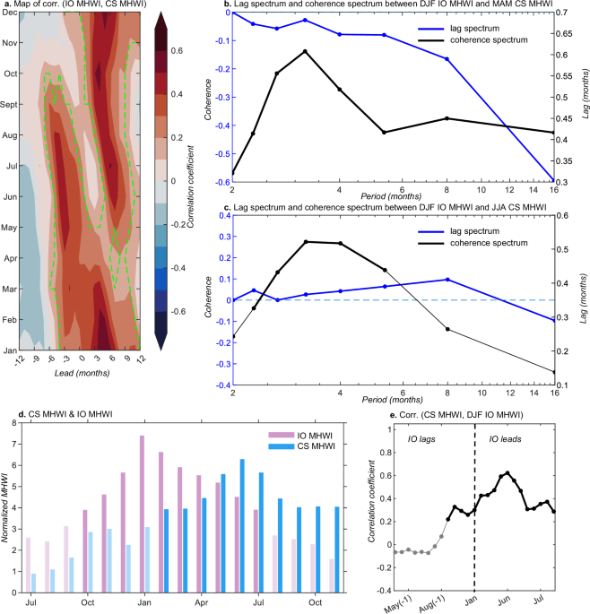
Marine heatwaves can interact across ocean basins through atmospheric teleconnections, but such inter-basin links remain poorly understood. Here we show that boreal spring and summer marine heatwaves in the Caribbean Sea are significantly connected to marine heatwaves in the Indian Ocean during the preceding winter. Using observational data and climate model simulations, we identify that boreal winter Indian Ocean marine heatwaves trigger atmospheric convection, generating an eastward-propagating Indo-Pacific-Atlantic Rossby wave train. This wave train alters the regional Hadley circulation and renders the overlying atmosphere warm, moist, and stable over the Caribbean Sea, reducing latent heat loss from the ocean, driving sea surface warming and promoting the intensification of marine heatwaves. These findings reveal a robust teleconnection pathway that allows climate signals from one basin to amplify marine heatwaves in another.
Local drivers in accelerating North American heat stress
Authors: Andreas F. Prein, Qinqin Kong, Gabriele Villarini, James M. Done, David R. Johnson et al.
Journal: Nature Communications · DOI: 10.1038/s41467-026-72795-w
Matched topics: climate change
Climate change increases heat extremes, threatening human health and economies. Using reanalysis data and climate simulations, we show that since the 1940s, population exposure to extreme heat (wet-bulb globe temperature > 32 °C) has increased by 21% in the U.S. At 2 °C of global warming, exposure increases by 273% because heat-stress frequency increases exponentially with warming. Additionally, 2 °C warming leads to increased nighttime heat stress and decreased work capacity, indicating severe health and economic impacts. Heat stress rises fastest in high-latitude areas, while humid regions experience the greatest exposure increases. In northern regions, heatwave frequency increases with warming, whereas in southern regions, events merge into month-long heatwaves. Increasing temperatures and humidity, along with decreasing wind speed, influence regional heat stress, underscoring the need for tailored adaptation strategies. Overall, heat stress exposure is projected to escalate with additional warming, underscoring the need for mitigation and adaptation to protect vulnerable populations.
Compounding hazards increase flood economic losses across Europe
Authors: Michele Ronco, Aloïs Tilloy, Christina Corbane, Damien Delforge, Luc Feyen et al.
Journal: Nature Communications · DOI: 10.1038/s41467-026-73248-0
Matched topics: river, flood
Compound events—combinations of multiple hazards contributing to societal or environmental risk—can significantly exacerbate disaster impacts, yet their effect on flood-related losses remains poorly quantified. Using a pan-European multi-hazard dataset spanning 1981–2020 at sub-national resolution, we find that more than 70% of recorded flood events involve compounding hazards, including meteorological extremes such as heatwaves and windstorms, alongside anomalous river discharge, with an increasing trend over time. The top 1% of events by economic losses are all compound, with total losses exceeding 167 billion euros above single-hazard floods. We introduce a compound hazard complexity metric and combine it with regional exposure and vulnerability data. Applying an ensemble machine learning model with explainable AI and a Double Machine Learning Causal Forest, we show that regions with higher complexity experience greater losses, even after controlling for flood magnitude and vulnerability, highlighting the importance of compound hazard information in risk modeling.
Addressing global hotspots of drought-related crop production losses
Authors: Marta Tuninetti, Kyle Frankel Davis
Journal: Nature Communications · DOI: 10.1038/s41467-026-72715-y
Matched topics: drought, climate change, irrigation
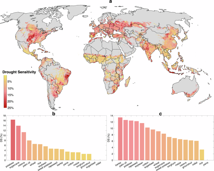
Meeting future food demand requires transforming food systems to simultaneously increase production, reduce environmental impacts, and adapt to climate change. As climate variability increasingly affects production stability, understanding where cropping patterns are vulnerable to hydroclimatic stress is a missing but critical step toward improving agricultural production resilience. Here we combine gridded climate data, spatially explicit agricultural statistics, and empirical water-production functions to quantify global patterns of rainfed and irrigated crop-specific Drought Sensitivity—defined as the percent reduction in median yield under extreme hydroclimatic conditions—and drought-associated losses for 17 major crops, representing 75% of global production. This metric identifies locations where crops experience high climate variability and are most susceptible to drought-related losses. We estimate global losses of −10.1% and −6.8% in median rainfed and irrigated production, respectively, under historically observed extremes—enough calories to feed 2.1 billion people—and identify hotspots in the central US, eastern Brazil, the Mediterranean, and South Asia. Focusing on monsoon cereals (rice, maize, millet, sorghum), we show that sustainable irrigation expansion and targeted crop switching could avoid 62% of rainfed losses while increasing median production by 14%. This scalable framework enables proactive targeting of mitigation actions and investments to stabilize and increase global crop supply.
Role of Earth system processes in the relationship between climate change and cumulative carbon emissions
Authors: Spencer K. Liddicoat, Timothy Andrews, Chris D. Jones, Lina M. Mercado, Mark A. Ringer et al.
Journal: Nature Communications · DOI: 10.1038/s41467-026-72930-7
Matched topics: climate change, earth system model
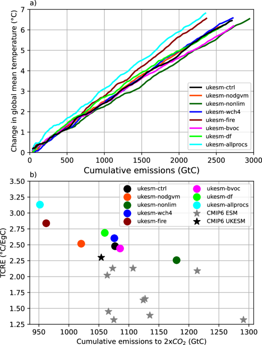
Estimates of carbon emissions budgets to limit global warming to 1.5 °C or 2 °C rely on the near-linear relationship between global temperature change and total CO2 emitted, known as the Transient Climate Response to cumulative CO2 Emissions (TCRE). The TCRE is determined from Earth System Models (ESMs) and is therefore sensitive to the physical and biogeochemical processes represented within them. Here we use an ESM (UKESM) to explore the sensitivity of TCRE to six Earth system processes in isolation. Four processes increase TCRE: fire-vegetation interactions by 14.6%; nitrogen limitation of vegetation by 9.7%; diffuse radiation effects on vegetation by 8.5%; and interactive emissions of methane from wetlands by 5.1%. Conversely, two processes marginally reduce TCRE: allowing the vegetation distribution to adapt to changing climate and CO2 lowers TCRE by 1.5%, and climate impacts from the emission of biogenic volatile organic compounds reduce it by 1.4%. We demonstrate the extent to which each process changes TCRE via its influence on the climate and on the global carbon cycle, and discuss underlying mechanisms. Our results highlight the substantial process-dependence of model-derived estimates of TCRE, with implications for remaining carbon budgets to future warming targets calculated from them.
The accelerating loss and shifting dynamics of US tidal wetlands
Authors: Xiucheng Yang, Shi Qiu, Kevin D. Kroeger, Zhiliang Zhu, Scott Covington et al.
Journal: Nature Communications · DOI: 10.1038/s41467-026-71464-2
Matched topics: river, coastal
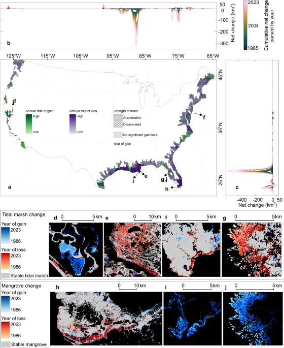
Tidal wetlands are critical ecosystems for coastal sustainability, yet despite growing regulatory protection, they continue to decline globally. Their long-term resilience to interacting chronic stressors and extreme events remains uncertain, in part because comprehensive, high-frequency monitoring has been lacking. While direct land-use conversion has been substantially restricted in the United States, the true trajectory of these protected habitats has remained unclear. Here, we use four decades of high-resolution satellite records to analyze the shifting dynamics of US tidal wetlands. We reveal a widespread and previously unquantified acceleration in the rate of tidal wetland loss, amounting to a net loss of −1640 km² at the rate of −40.53 km² year⁻¹, accelerating by −0.73 km² year⁻², of which tidal marsh contributed the majority of this loss with a cumulative decline of 1567 km². Furthermore, we show that the drivers of this decline are shifting: while chronic stressors like relative sea level rise have caused the largest cumulative loss (~60% of the total area loss), acute shocks from extreme weather now dominate (1.4 times that of the chronic stressors) the acceleration of that loss. By contrast, direct human activities were a minor driver, accounting for only 4% of total observed losses. These findings indicate that the resilience of these protected ecosystems is declining. It provides an urgent warning that existing conservation strategies, initially concerned with direct human impacts and increasingly focused on relative sea level rise as a slow-moving pressure, are ill-equipped for a future of increasing extreme weather events and highlights the need to redesign adaptation policies.
Statistics
| Metric | Count |
|---|---|
| Journals searched | 11 |
| Total papers fetched | 123 |
| Passed deterministic filter | 15 |
| After LLM relevance filtering | 9 |
| Rejected (not relevant) | 6 |
| AI for Science items picked | 0 |
Papers by journal
| Journal | Papers |
|---|---|
| Nature | 1 |
| Geophysical Research Letters | 2 |
| Nature Communications | 5 |
| Nature Climate Change | 0 |
Filtering Criteria
Topics: hydrology, hydrologic model, river, runoff, streamflow, reservoir, water management, flood, drought, seasonal, land surface model, climate change, hydropower, surface water, irrigation, earth system model, estuary, coastal, freshwater discharge, river plume, ocean biogeochemistry, marine heatwave, paleohydrology, paleoclimate, Quaternary, Holocene, Pleistocene, fluvial geomorphology, river terrace, loess, drainage network, river capture, landscape evolution, luminescence dating
Fields: engineering, environmental science, computer science, geology, geography