Paper Harvest Report
Date range: June 03, 2026
3 top-tier papers selected out of 118 total publications
Today’s Highlights
Today’s three papers span planetary climate constraints, coastal sea-level dynamics, and mountain hydrology infrastructure. A Nature study reveals a previously unknown east–west albedo symmetry in Earth’s radiation budget, providing a reduced-degree-of-freedom constraint for Earth System Models and linking interannual variability to ENSO. A GRL paper shows that gravitational self-attraction and solid Earth deformation from dynamic ocean mass redistribution can amplify projected regional sea-level change by ~15% along continental shelves—a component absent from standard projections. BAMS documents the modernization of the historic Central Sierra Snow Laboratory, now equipped with a comprehensive sky-to-stream observation system extending manual snowpack records dating to 1878.
Table of Contents
Top-Tier Journal Papers
Earth’s east–west albedo symmetry
Authors: Jianhao Zhang, Jake J. Gristey, Graham Feingold
Journal: Nature · DOI: 10.1038/s41586-026-10624-2
Matched topics: earth system model
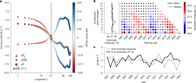
Earth’s albedo is fundamental to the planetary energy budget. The Northern Hemisphere (NH) and Southern Hemisphere (SH) contribute essentially equally to the planetary albedo—a remarkable yet puzzling phenomenon known as hemispheric albedo symmetry. Although such symmetry is rare, it is not unique. Nevertheless, other symmetry pairs have remained unexplored, despite their potential to illuminate possible causes of albedo symmetries and implications for the planetary energy budget. Using a 25-year satellite record, here we show that Earth also exhibits a unique and persistent east–west (E–W) albedo symmetry: the 27° E meridian divides the planet into an Eastern Hemisphere (EH) and a Western Hemisphere (WH) that reflect nearly identical amounts of sunlight. In contrast to the NH–SH symmetry, the EH–WH symmetry encapsulates a distinctive ‘triple symmetry’ in which clear-sky albedo, cloud radiative effect and open-ocean fraction all exhibit hemispheric symmetry around this meridian. This EH–WH symmetry arises from greater high-cloud reflection in the EH balancing greater low-cloud reflection in the WH. Furthermore, interannual variability in the EH–WH symmetry tracks the phase of the El Niño–Southern Oscillation (ENSO), indicating a potential connection to general circulation. This discovery of the EH–WH albedo symmetry and its emergence as a triple symmetry provides a reduced degree-of-freedom constraint for Earth system models (ESMs) and stresses the critical nature of continued Earth radiation budget observations under a rapidly changing climate.
Crustal Deformation and Gravitational Effects From Dynamic Ocean Mass Redistribution Impact Projected Sea‐Level Change
Authors: Grace Ertel, Sophie Coulson, Christopher G. Piecuch, Matthew Hoffman
Journal: Geophysical Research Letters · DOI: 10.1029/2026gl122243
Matched topics: coastal
As the climate warms, associated changes in ocean dynamics will redistribute sea‐water mass within the ocean, contributing to relative sea‐level change. This mass redistribution will cause additional sea‐level changes due to gravitational self‐attraction, deformation of the solid Earth, and shifts in the Earth’s rotation axis (GRD), which are not incorporated in sea‐level projections. Using CMIP6 climate model output, we quantify relative sea‐level changes induced by GRD from ocean‐dynamic mass loading through 2100. These effects act to amplify projected ocean‐dynamic sea‐level patterns, causing sea‐level rise in coastal regions, particularly along wide continental shelves and at high latitudes. On average, the magnitude of such GRD‐induced sea‐level change is equivalent to ∼15% of the signal due to dynamic ocean mass redistribution. Although our results show substantial inter‐model spread, they reveal that GRD‐induced relative sea‐level changes from ocean mass redistribution represent a non‐negligible component of regional sea‐level change and should be considered in projections.
Modernization of the Central Sierra Snow Laboratory – A new chapter in a storied existence
Authors: Andrew Schwartz, Marianne Cowherd, Bruce McGurk, Megan Mason, Kristin Riker-Coleman, Brian Zutter, Gabriel Lewis
Journal: Bulletin of the American Meteorological Society · DOI: 10.1175/bams-d-25-0112.1
Matched topics: hydrology

The Central Sierra Snow Laboratory (CSSL) has been conducting atmospheric and hydrological research in the central Sierra Nevada mountains of California at an elevation of 2129 meters since 1946. Now managed and operated by the University of California, Berkeley, the laboratory has embarked on a new era with emphases on the research-to-operations pipeline, scientific transparency, and expanded collaboration. This has led to substantial investments in comprehensive atmospheric and hydrological observation systems, new and expanded research and teaching programs, and increased collaboration. The data collected at CSSL are invaluable for the hydrometeorological community. These data include manual measurements of snowfall accumulation and maximum snowpack depth, which extend records started in 1878 by the Central Pacific Railroad – believed to be some of the longest of their kind in the world. CSSL is unique as it has a full time on-site staff that make sub-daily manual observations of snowfall and snow water equivalent. Recent investment in instrumentation has created the Sky-To-Stream System with full measurement of snowpack energy and mass balances, which allows the site to act as a testbed for new instrumentation and a location for model evaluation. This article broadly discusses three primary aspects of CSSL: 1) its history and contributions to hydrology, meteorology, and climatology, 2) recent investments to re-establish the lab as a world-class research facility, and 3) its new community outreach initiatives.
AI for Science
How AI is changing research
- How an astrophysicist uses Codex to help simulate black holes (OpenAI Blog, 2026-06-11) — Astrophysicist Chi-kwan Chan describes using OpenAI’s Codex agent to write and iterate on simulation code for black-hole physics, compressing multi-day development cycles to hours. Earth-system modelers running E3SM, MOSART, or WRF face exactly the same bottleneck — dense Fortran/C++ codebases with steep on-ramp times — making AI coding agents a high-value force-multiplier for the same class of compute-heavy simulation work.
Cross-discipline sparks
- Deep learning four decades of human migration (Nature, 2026-06-10) — A deep-learning model fuses 230-country, 34-year migration flows from heterogeneous, incomplete sources into an annual gridded dataset with calibrated uncertainty. The methodological template — multi-source data fusion with deep learning for a globally sparse phenomenon — maps directly onto continental-to-global hydrologic reconstruction: estimating historical streamflow, precipitation, or groundwater recharge where gauge networks are thin. A small earth-science team with access to foundation-model recipes and off-the-shelf training frameworks could plausibly attempt this now.
Statistics
| Metric | Count |
|---|---|
| Journals searched | 11 |
| Total papers fetched | 118 |
| Passed deterministic filter | 7 |
| After LLM relevance filtering | 3 |
| Rejected (not relevant) | 4 |
| AI for Science items picked | 2 |
Papers by journal
| Journal | Papers |
|---|---|
| Nature | 1 |
| Geophysical Research Letters | 1 |
| Bulletin of the American Meteorological Society | 1 |
Filtering Criteria
Topics: hydrology, hydrologic model, river, runoff, streamflow, reservoir, water management, flood, drought, seasonal, land surface model, climate change, hydropower, surface water, irrigation, earth system model, estuary, coastal, freshwater discharge, river plume, ocean biogeochemistry, marine heatwave, paleohydrology, paleoclimate, Quaternary, Holocene, Pleistocene, fluvial geomorphology, river terrace, loess, drainage network, river capture, landscape evolution, luminescence dating
Fields: engineering, environmental science, computer science, geology, geography