Paper Harvest Report
Date range: May 28, 2026
8 top-tier papers selected out of 131 total publications
Today’s Highlights
A Nature Water perspective by Günter Blöschl proposes five principles for hydrology in the era of managed waters, offering a timely conceptual framework as human control over the global water cycle intensifies. From Geophysical Research Letters, four complementary studies cover shifting flood-generation mechanisms in snow-dominated catchments under warming, a machine-learning approach for mapping interannual irrigated area variability essential for Earth system models, NASA’s PACE satellite demonstrating promise for detecting harmful cyanobacterial toxins in freshwater, and a fair-weather sampling bias in coastal suspended sediment remote sensing. On the paleoclimate side, Nature Communications links Holocene cold events to volcanic forcing while Nature Geoscience quantifies the enhanced sensitivity of the Antarctic Ice Sheet to CO₂ drawdown across the Mid-Pleistocene Transition.
Table of Contents
- Today’s Highlights
- Top-Tier Journal Papers
- Five principles for hydrology in the era of managed waters
- Mapping the Interannual Variability of Irrigated Area Using Categorical Sampling and Machine Learning
- Changing Flood‐Generating Mechanisms Impact Flood Characteristics in Snow‐Dominated Catchments
- Initial Assessment of the Detectability of Cyanotoxin Occurrence Using PACE Satellite Observations
- Global Fair‐Weather Bias in Remotely Sensed Coastal Suspended Sediment Concentration
- A Coordinated Framework for Global Climate Reanalyses
- Increased sensitivity of the Antarctic Ice Sheet to decreasing CO2 across the Mid-Pleistocene Transition
- Evidence for volcanic forcing of Holocene cold events
- AI for Science
- Statistics
- Filtering Criteria
Top-Tier Journal Papers
Five principles for hydrology in the era of managed waters
Authors: Günter Blöschl
Journal: Nature Water · DOI: 10.1038/s44221-026-00657-2
Matched topics: hydrology

Abstract not available.
Mapping the Interannual Variability of Irrigated Area Using Categorical Sampling and Machine Learning
Authors: Xin Tian, Jianzhi Dong, Yuanyuan Zha, Jianhong Zhou, Dexing Zhao, Xi Chen et al.
Journal: Geophysical Research Letters · DOI: 10.1029/2026gl123935
Matched topics: water management, earth system model
Accurate irrigated area (IA) mapping is essential for hydrological and climate modeling. However, existing IA mapping approaches typically rely on persistently irrigated or non‐irrigated samples, which has reduced sensitivity to year‐to‐year IA variability. Here, we develop a Categorical Triple Collocation (CTC) method that uses categorical data to extract time-varying irrigated and non-irrigated samples without relying on persistent category assumptions. CTC leverages the statistical relationships among multiple datasets to identify annually varying irrigated areas, enabling more accurate and dynamic IA mapping across diverse agricultural regions. Our validation demonstrates that this approach significantly improves the detection of interannual IA changes compared to existing methods, particularly in regions with variable irrigation practices. This method provides a valuable tool for improving the representation of irrigation in hydrological and Earth system models.
Changing Flood‐Generating Mechanisms Impact Flood Characteristics in Snow‐Dominated Catchments
Authors: Xinli Bai, Wenbin Liu, Zhiyang Lan, Tingting Wang, Hong Wang, Yao Feng et al.
Journal: Geophysical Research Letters · DOI: 10.1029/2026gl121879
Matched topics: water management, flood
Global warming is shifting the characteristics of snowmelt floods, while simultaneously altering flood‐generating mechanisms in cold regions. Here, we disentangle the contributions of inter‐type mechanism transitions from intra‐type characteristic shifts to overall changes in flood behavior across Northern Hemisphere snow‐dominated catchments. We find that both inter‐type transitions (e.g., from snowmelt‐dominated to rain‐on‐snow or rain‐dominated flooding) and intra‐type shifts in flood timing and magnitude contribute substantially to changing flood characteristics. Regions experiencing the largest changes are concentrated in transitional snow zones, where warming pushes catchments across critical thresholds in flood‐generating processes. These findings have important implications for flood risk assessment and water management in cold regions under continued warming.
Initial Assessment of the Detectability of Cyanotoxin Occurrence Using PACE Satellite Observations
Authors: Denesh Karunakaran, Ardeshir Ebtehaj, Lucas Clark Burnette, Miki Hondzo, Leif Olmanson
Journal: Geophysical Research Letters · DOI: 10.1029/2026gl122098
Matched topics: seasonal
Microcystin is a major public health hazard during freshwater cyanobacterial blooms, yet its remote detection remains challenging because it lacks any direct optical absorption features. We demonstrate that hyperspectral observations from NASA’s PACE Ocean Color Instrument (OCI) can be used to detect cyanotoxin occurrence in freshwater environments by exploiting spectral co-variation patterns associated with bloom conditions. Using field measurements and radiative transfer simulations, we show that PACE OCI’s high spectral resolution enables distinguishing bloom conditions associated with elevated microcystin from non-toxic algal proliferations. These findings represent a first step toward operational satellite-based early warning systems for harmful cyanobacterial toxins in lakes and reservoirs, with significant implications for drinking water safety and ecosystem monitoring.
Global Fair‐Weather Bias in Remotely Sensed Coastal Suspended Sediment Concentration
Authors: Hangjie Lin, Cédric G. Fichot, Yunwei Wang, Qian Yu, Aijun Wang, Shu Gao
Journal: Geophysical Research Letters · DOI: 10.1029/2026gl122332
Matched topics: coastal
Satellite estimates of suspended‐sediment concentration (SSC) are widely used to understand ecosystem functions and resilience of coastal environments. Yet, they rely largely on fair‐weather observations. Combining continuous in situ time series with multi‐decadal satellite records and reanalysis products, we show that the global satellite SSC climatology is systematically biased low—by a factor of 2 to 5 in many regions—because storms and high-turbidity events that dominate sediment flux are precisely the conditions under which optical satellites cannot observe. The bias varies seasonally and geographically, being largest in high-latitude, energetic coastal environments. We propose correction approaches based on modeled wave energy and wind fields that substantially reduce the bias and suggest that coastal SSC budgets derived purely from satellites are systematically underestimated globally.
A Coordinated Framework for Global Climate Reanalyses
Authors: Alison Cobb, Michael G. Bosilovich, Carlo Buontempo, Hans Hersbach, Shinya Kobayashi, Yuki Kosaka et al.
Journal: Bulletin of the American Meteorological Society · DOI: 10.1175/bams-d-25-0056.1
Matched topics: seasonal

Climate reanalyses combine historical observational data with advanced modeling techniques to create long-term, consistent climate datasets. Such global datasets are produced by several international centers and have a large and diverse range of applications. The World Meteorological Organization (WMO) recognized the strategic importance of reanalyses by establishing a coordination framework to improve their consistency, quality, and usability. This paper describes the objectives and structure of this coordinated framework, the current status of global reanalyses, and plans for future coordination activities. Key elements include harmonized evaluation metrics, shared benchmarking datasets, and coordinated uncertainty assessment. The framework aims to improve end-user understanding of reanalysis quality and to facilitate the selection of appropriate products for specific applications in climate monitoring, seasonal forecasting, and Earth system model evaluation.
Increased sensitivity of the Antarctic Ice Sheet to decreasing CO2 across the Mid-Pleistocene Transition
Authors: Kyung-Sook Yun, Axel Timmermann
Journal: Nature Geoscience · DOI: 10.1038/s41561-026-01979-2
Matched topics: Pleistocene
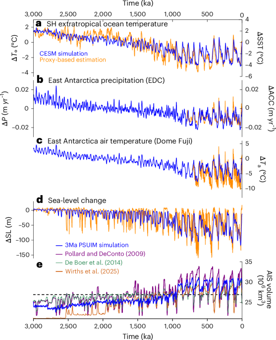
Abstract not available.
Evidence for volcanic forcing of Holocene cold events
Authors: Alice R. Paine, James U. L. Baldini, Charlie L. Rex, Michael Sigl, Francesco S. R. Pausata, Richard J. Brown
Journal: Nature Communications · DOI: 10.1038/s41467-026-73492-4
Matched topics: Holocene
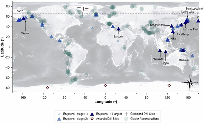
During the Holocene, the climatic stability of the northern hemisphere was intermittently disrupted by centennial-scale cooling events, whose origins remain unclear. Explosive volcanism is a plausible trigger, yet its potential to drive longer-term (centennial-to-millennial) climatic effects has been questioned. Here, we present a synthesis of volcanic records and palaeoclimate proxy data demonstrating that large volcanic eruptions systematically precede Holocene cold events by decades to centuries. Using a combination of ice-core tephra records, climate model simulations, and multi-proxy temperature reconstructions, we show that volcanic radiative forcing can initiate persistent cooling through feedbacks involving sea ice, ocean circulation, and vegetation. These results provide a causal mechanism for several enigmatic Holocene cold events and have implications for understanding natural climate variability and the baseline against which anthropogenic forcing must be assessed.
AI for Science
How AI is changing research
- Amid a flood of AI advances, astrophysicists are questioning the soul of their field (Science, 2026-06-04) — Astrophysicists—like earth scientists—work in a data-heavy, pattern-recognition-intensive discipline, and this piece confronts the same question now pressing on hydrology and climate modeling: when AI discovers the pattern, who owns the understanding? The soul-searching happening in astrophysics is a preview of debates coming to ESM and hydrologic communities as ML emulators replace process-based components.
Cross-discipline sparks
- A universal foundation model for grounded biomedical image interpretation (Nature Communications, 2026-06-04) — This model learns to localize and answer natural-language queries about specific regions within biomedical images—grounded interpretation rather than whole-image classification. The same recipe is directly transplantable to multispectral satellite imagery: pretrain on Sentinel-2 or MODIS tile archives, fine-tune to answer spatial questions like “identify flooded pixels in this sub-basin” or “estimate vegetation stress in this irrigated district.” The architecture is now off-the-shelf; the remaining barrier for a small earth-science team is labeled training data, which remote-sensing campaigns increasingly supply.
Statistics
| Metric | Count |
|---|---|
| Journals searched | 11 |
| Total papers fetched | 131 |
| Passed deterministic filter | 17 |
| After LLM relevance filtering | 8 |
| Rejected (not relevant) | 9 |
| AI for Science items picked | 2 |
Papers by journal
| Journal | Papers |
|---|---|
| Geophysical Research Letters | 4 |
| Nature Water | 1 |
| Nature Geoscience | 1 |
| Nature Communications | 1 |
| Bulletin of the American Meteorological Society | 1 |
Filtering Criteria
Topics: hydrology, hydrologic model, river, runoff, streamflow, reservoir, water management, flood, drought, seasonal, land surface model, climate change, hydropower, surface water, irrigation, earth system model, estuary, coastal, freshwater discharge, river plume, ocean biogeochemistry, marine heatwave, paleohydrology, paleoclimate, Quaternary, Holocene, Pleistocene, fluvial geomorphology, river terrace, loess, drainage network, river capture, landscape evolution, luminescence dating
Fields: engineering, environmental science, computer science, geology, geography