Paper Harvest Report
Date range: May 22, 2026
4 top-tier papers selected out of 86 total publications
Today’s Highlights
Rapid drought-to-flood weather whiplash events are intensifying under climate change, exposing governance failures in water management across Latin America (Nature Water). Meanwhile, SWOT satellite observations are revealing previously invisible fine-scale ocean transport pathways in the South China Sea, opening new avenues for understanding nutrient redistribution and biological connectivity. A new supplemental X-band radar network promises to fill critical coverage gaps for flood detection across the US.
Table of Contents
Top-Tier Journal Papers
Rapid drought-to-flood weather whiplash amplifies climate change governance failure
Authors: Ricardo Sánchez-Murillo, Christian Birkel, Luis Gimeno, Miguel A. Mejía-González, Dimitris A. Herrera, Roberto Kirchheim et al.
Journal: Nature Water · DOI: 10.1038/s44221-026-00653-6
Matched topics: flood, drought, climate change
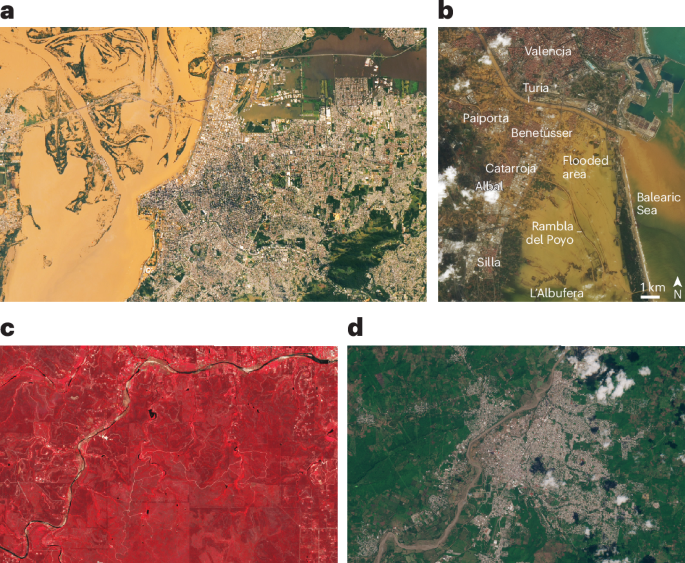
Abstract not available.
Predicting Head Loss and Hydraulic Roughness of Channel‐Spanning Large Wood Jams
Authors: Aleah Hahn, Ryan R. Morrison, Shayla Triantafillou, Ellen Wohl
Journal: Geophysical Research Letters · DOI: 10.1029/2026gl122411
Matched topics: river
Log jams enhance hydraulic and geomorphic diversity in river corridors. Channel‐spanning log jams induce backwatering, increase local flow heterogeneity, promote sediment deposition, and improve aquatic habitat diversity. Despite their increasing popularity in river restoration, predicting their hydraulic effects remains a challenge. We developed a model to predict dimensionless head loss through log jams for sub‐bankfull flows as traditional backwater methods are limited in variable natural channels. We developed the model from historical flume studies and tested the model application on field data from natural jams. As solid volume fraction increased, we found that dimensionless head loss also increased. Field application of our model successfully predicted head loss in naturally occurring log jams. Roughness values (Manning’s and Darcy‐Weisbach ) varied but generally decreased with increased unit discharge. Our approach for determining head loss and roughness allows for better prediction and design of the localized hydraulic impacts of log jams.
Hidden Fine‐Scale Transport Pathways and Biological Connectivity Revealed by SWOT
Authors: Yunchen Liu, Qingyou He, Weikang Zhan, Zhiwei Zhang, Giulia Vecchioni, Yiqiang Hu et al.
Journal: Geophysical Research Letters · DOI: 10.1029/2025gl121208
Matched topics: surface water
Oceanic currents redistribute nutrients, phytoplankton, and other biogenic materials, fundamentally shaping marine biodiversity and ecosystem functioning. Yet, the topology of fine‐scale material transport remains poorly resolved due to limitations in high‐resolution flow observations. Here, by constructing Lagrangian flow networks from the Surface Water and Ocean Topography (SWOT) observations, we analyze surface fine‐scale transport features in the South China Sea in 2023. Compared with networks derived from conventional altimetry products, SWOT‐derived networks identify more sinks, sources, and transport gateways at 2–10‐day timescales and spatial scales below ∼60 km (90 km) in summer (winter). As such, SWOT resolves hydrodynamic provinces that remain invisible to conventional altimetry, revealing previously undetected corridors and barriers of surface exchange. This advantage also provides better dynamic explanations for complex phytoplankton community structures and evolution. Our results highlight SWOT’s transformative capacity to improve the diagnosis and prediction of ocean material transport, opening new avenues for interdisciplinary oceanographic and ecological applications.
A Supplemental High Resolution Weather Radar Network for the Conterminous United States
Authors: Micheal Simpson, Jon Van Doore, Daniel Cookes, Marlon Daquel, Dale Francis, Tara Goode et al.
Journal: Bulletin of the American Meteorological Society · DOI: 10.1175/bams-d-24-0168.1
Matched topics: flood
Weather radar is an essential observation tool that facilitates real-time situational awareness of the atmosphere providing forecasters with critical information to issue watches and warnings. In the continental United States, the WSR-88D and TDWR networks have been operating for several decades and have provided a significant improvement in the detection of severe weather including, but not limited to, tornadoes, hail, severe wind, and flash flooding with continuing research to operations. Despite the impressive capabilities of the radars, there are many areas within the CONUS where radar coverage is inadequate for proper low-level analyses of the atmosphere. In addition, with changing weather and climate patterns, the need for coverage in previously underserved areas has increased. The National Weather Service has announced plans for a future radar network that will replace the existing aging network and could consist of a hybrid network of radars, transmitting at different wavelengths and consisting of a mix of federal and non-federal radar networks. Climavision, a U.S. based weather and climate start-up, is in the process of establishing a supplemental radar network throughout the United States that will consist of upwards of 200 polarimetric X-band radars. This paper provides an overview of the supplemental radar network and presents preliminary results from the fleet.
Statistics
| Metric | Count |
|---|---|
| Journals searched | 11 |
| Total papers fetched | 86 |
| Passed deterministic filter | 10 |
| After LLM relevance filtering | 4 |
| Rejected (not relevant) | 6 |
| AI for Science items picked | 0 |
Papers by journal
| Journal | Papers |
|---|---|
| Nature Water | 1 |
| Geophysical Research Letters | 2 |
| Bulletin of the American Meteorological Society | 1 |
Filtering Criteria
Topics: hydrology, hydrologic model, river, runoff, streamflow, reservoir, water management, flood, drought, seasonal, land surface model, climate change, hydropower, surface water, irrigation, earth system model, estuary, coastal, freshwater discharge, river plume, ocean biogeochemistry, marine heatwave, paleohydrology, paleoclimate, Quaternary, Holocene, Pleistocene, fluvial geomorphology, river terrace, loess, drainage network, river capture, landscape evolution, luminescence dating
Fields: engineering, environmental science, computer science, geology, geography