Paper Harvest Report
Date range: July 18, 2026
2 top-tier papers selected out of 35 total publications
Today’s Highlights
A global satellite and deep-learning analysis reveals that nearly 20% of the world’s 7.52 million km of riverfronts have been anthropogenically modified—primarily by agriculture (13.43%) and built-up areas (6.29%)—with a concentrated modification belt spanning parts of Africa and Eurasia responsible for ~60% of global alterations. In parallel, SWOT high-rate raster data demonstrates new capabilities for monitoring Antarctic ice shelf dynamics at 21-day repeat intervals, capturing tidal responses, grounding zone flexure, and crevasse deepening—processes critical for constraining ice loss and sea-level projections.
Table of Contents
Top-Tier Journal Papers
Human imprints on global riverfronts
Authors: Fanxuan Zeng, Chunqiao Song, R. Iestyn Woolway, Linghong Ke, Jida Wang, Dongmei Feng et al.
Journal: Nature Communications · DOI: 10.1038/s41467-026-75777-0
Matched topics: river
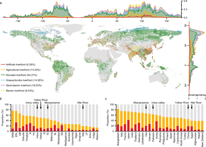
Rivers are profoundly shaped by human activity along their water-land interfaces (riverfronts), yet the global distribution and drivers of these imprints remain poorly understood. Here we present a high-resolution global map of 7.52 million kilometers of riverfronts using satellite imagery and deep learning. We find that nearly 20% of global riverfronts are anthropogenically modified, primarily by agriculture (13.43%) and built-up areas (6.29%). A distinct modification belt spans parts of Africa and Eurasia, accounting for ~60% of global alterations, with imprint densities six times higher than elsewhere. This lateral fragmentation represents a pervasive human pressure that differs fundamentally from dam-induced longitudinal fragmentation, and is closely linked to deteriorating water quality and biodiversity threats. Environmental constraints and region-specific socio-economic dependencies further shape these spatial patterns. Our findings inform riverfront management and underscore the urgent need to reconcile development with the ecological integrity of these transitional zones.
SWOT High‐Rate Raster Data Reveals Antarctic Ice Shelf Motion and Change in Response to Ocean and Ice Dynamics
Authors: S. L. Howard, Z. S. Katz, L. Padman, M. R. Siegfried, E. Abrahams, T. M. Snow
Journal: Geophysical Research Letters · DOI: 10.1029/2026gl122539
Matched topics: surface water
The NASA/CNES Surface Water and Ocean Topography (SWOT) swath‐mapping radar altimetry satellite mission, launched in December 2022, provides repeat‐track coverage to about ±78.2° latitude every 21 days, sampling many of Antarctica’s most dynamic ice shelves that play key roles in constraining mass loss from the grounded ice sheet. Understanding how ice‐shelf extent and thickness respond to forcings requires three‐dimensional mapping of ice structure at the short time and space scales of major mass change processes including basal and surface mass balances, and crevasse growth. We demonstrate that repeated SWOT high‐rate acquisitions can accurately monitor changes in ice‐shelf surface heights, revealing key processes including responses to ocean tides and atmospheric forcing, ice flexure along grounding zones, and crevasse deepening, that affect stresses impacting ice loss. Despite limitations in acquisition and processing, some of which are being addressed, the SWOT mission provides exciting new opportunities for studying ice‐shelf dynamics.
Statistics
| Metric | Count |
|---|---|
| Journals searched | 11 |
| Total papers fetched | 35 |
| Passed deterministic filter | 5 |
| After LLM relevance filtering | 2 |
| Rejected (not relevant) | 3 |
| AI for Science items picked | 0 |
Papers by journal
| Journal | Papers |
|---|---|
| Nature Communications | 1 |
| Geophysical Research Letters | 1 |
Filtering Criteria
Topics: hydrology, hydrologic model, river, runoff, streamflow, reservoir, water management, flood, drought, seasonal, land surface model, climate change, hydropower, surface water, irrigation, earth system model, estuary, coastal, freshwater discharge, river plume, ocean biogeochemistry, marine heatwave, paleohydrology, paleoclimate, Quaternary, Holocene, Pleistocene, fluvial geomorphology, river terrace, loess, drainage network, river capture, landscape evolution, luminescence dating
Fields: engineering, environmental science, computer science, geology, geography