Paper Harvest Report
Date range: July 23, 2026
3 top-tier papers selected out of 139 total publications
Today’s Highlights
A Nature Communications study delivers a striking indictment of historical redlining: D-graded neighborhoods in U.S. cities face 100-year flood exposure at rates exceeding what A-graded residents experience at the 1000-year level — and high-resolution flood modeling shows infrastructure deficits compound the disparity well beyond simple proximity to waterways. Nature Climate Change quantifies a largely untracked carbon source: CO₂ emitted by vessels navigating inland river networks globally. Geophysical Research Letters rounds out the day with evidence that forest loss warms land surfaces nearly twice as much as equivalent forest gain cools them, a key asymmetry for climate mitigation accounting.
Table of Contents
Top-Tier Journal Papers
Disproportionate exposure to extreme floods in historically redlined U.S. communities
Authors: Elizabeth Appel, S. Amin Enderami, Elaina J. Sutley, Admin Husic
Journal: Nature Communications · DOI: 10.1038/s41467-026-76024-2
Matched topics: river, flood
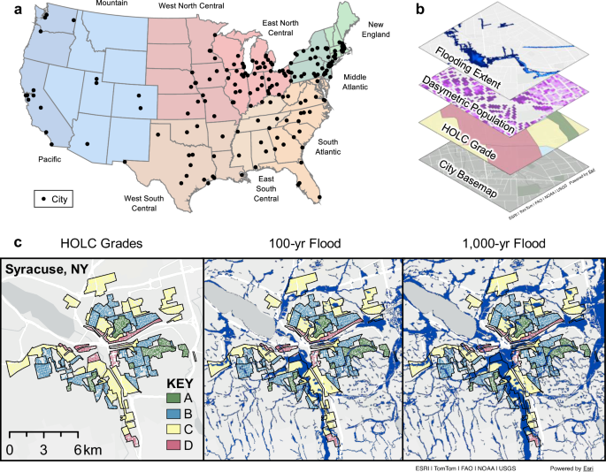
Extreme floods and historical public policies both leave lasting impacts. We analyzed flood exposure across the neighborhoods of 202 US cities historically assessed for lending risk by the Home Owners’ Loan Corporation on a scale from ‘best’ (A) to ‘hazardous’ (D). Using high-resolution flood modeling and dasymetric population mapping, we found that D-graded neighborhoods bear a disproportionate flood burden in roughly three-quarters of cities. This inequality follows a systematic gradient: A- and B-graded neighborhoods are underrepresented in the flooded population, C-graded neighborhoods are proportionately represented, and D-graded neighborhoods are overrepresented. A greater fraction of D-graded residents are exposed to the 100-yr flood (6.4%) than A-graded residents to the 1000-yr flood (5.9%) with the gap widening at higher-magnitude floods. Flood disparities are most pronounced in the Midwest and Mid-Atlantic regions, aligning with the historical concentration of industrial labor and redlined neighborhoods along waterways. However, we find that proximity to waterways alone does not explain the observed inequality: flood disparities persist even among neighborhoods far from major rivers and coasts, implicating infrastructure deficits as a compounding factor. Neighborhoods marked as ‘hazardous’ nearly a century ago remain disproportionately vulnerable today, underscoring the need for equitable urban planning.
Global vessel carbon dioxide emission from navigable rivers
Authors: Dawei Lu, Di Zhang, Shuwu Wang, Haotian Wang, Zhiyi Min, Xiangyu Li et al.
Journal: Nature Climate Change · DOI: 10.1038/s41558-026-02718-6
Matched topics: river
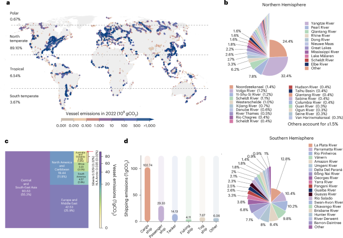
Abstract not available.
Asymmetry of Land Surface Temperature Response to Forest Gain and Loss: The Role of Land Cover Conversions
Authors: Yuehan Yu, Yan Li, Yiqing Liu, Duqi Liu, Hongwen Chen, Zijun Zhao
Journal: Geophysical Research Letters · DOI: 10.1029/2026gl123073
Matched topics: river
Recent studies reveal asymmetric land surface temperature (LST) responses to forest gain and loss, yet the role of underlying land cover conversions (LCC) remains unclear. Using three global land cover data sets (2001–2020), we quantify LST sensitivity to per unit forest loss and gain. Despite an overall warming caused by net forest cover loss, a consistent asymmetry emerges globally: the magnitude of LST sensitivity to forest loss (0.53°C) is nearly double that to forest gain (0.33°C) in the tropics, with a similar asymmetry in temperate and boreal regions after separating forest‐induced warming and cooling regions. This asymmetry arises from divergent LCC pathways between forest gain and loss, where forest loss often shifts to non‐forest land types (e.g., savanna/croplands), inducing greater LST changes than those reversed by equivalent forest gain (e.g., wetlands/grasslands). These demonstrate that LCC is an important driver of asymmetric LST responses, with key implications for forest‐based climate mitigation.
Statistics
| Metric | Count |
|---|---|
| Journals searched | 11 |
| Total papers fetched | 139 |
| Passed deterministic filter | 9 |
| After LLM relevance filtering | 3 |
| Rejected (not relevant) | 6 |
| AI for Science items picked | 0 |
Papers by journal
| Journal | Papers |
|---|---|
| Nature Communications | 1 |
| Nature Climate Change | 1 |
| Geophysical Research Letters | 1 |
Filtering Criteria
Topics: hydrology, hydrologic model, river, runoff, streamflow, reservoir, water management, flood, drought, seasonal, land surface model, climate change, hydropower, surface water, irrigation, earth system model, estuary, coastal, freshwater discharge, river plume, ocean biogeochemistry, marine heatwave, paleohydrology, paleoclimate, Quaternary, Holocene, Pleistocene, fluvial geomorphology, river terrace, loess, drainage network, river capture, landscape evolution, luminescence dating
Fields: engineering, environmental science, computer science, geology, geography