Paper Harvest Report
Date range: October 05, 2026
6 top-tier papers selected out of 83 total publications
Today’s Highlights
A standout study introduces a near-global dataset of river discharge rating curves and mean depths at 26,000+ locations derived from satellite radar altimetry, finally breaking the dependence on sparse in-situ gauge networks for large-scale hydrodynamic modeling. On the paleohydrology front, a 2,623-year temperature reconstruction from the Colorado Rocky Mountains reframes how warm and cool phases amplify or dampen droughts in the Colorado River and Rio Grande basins, with direct implications for long-range water resource planning. Urban hydrology also features with CROCUS Micronet, a DOE-supported sensor network capturing the coupled atmosphere-hydrosphere dynamics of Chicago at unprecedented spatial density.
Table of Contents
- Today’s Highlights
- Top-Tier Journal Papers
- Global scale river discharge and mean depth from radar altimetry and model
- A 2,623-year temperature reconstruction from the Colorado Rocky Mountains reveals warm and cool droughts
- CROCUS Micronet: A Distributed Urban Observation System in Chicago
- Global divergence in urban–rural vegetation resilience driven by broken ecological trade-offs
- Corals Reveal Atlantic Drivers of Red Sea Surface Variability Through Indian Ocean Inflow
- High‐ and Low‐Latitude Insolation Forcing Drives the Half‐Precession Cycle in Winter Arctic Sea Ice
- AI for Science
- Statistics
- Filtering Criteria
Top-Tier Journal Papers
Global scale river discharge and mean depth from radar altimetry and model
Authors: Adrien Paris, Pierre-André Garambois, Laetitia Gal, Arnaud Cerbelaud, Kévin Larnier, Cédric H. David et al.
Journal: Nature Communications · DOI: 10.1038/s41467-026-78275-5
Matched topics: river
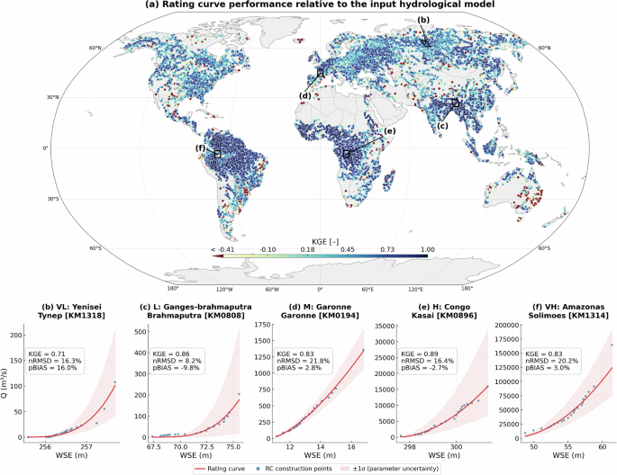
Rivers are vital for water security, yet scalable freshwater monitoring and global knowledge of river mean depth and discharge remains limited by sparse in situ data, satellite observations of river surface only and global river flow estimations relying on models with insufficient hydraulic information. Without a robust global product for river bathymetry derived from satellite altimetry, large-scale hydrodynamic assessments remain limited. Here we present a near-global dataset of discharge rating curves, and river mean depths at 26 000+ river locations, integrating satellite water elevation observations from multiple altimetry missions with a global hydrological model.
A 2,623-year temperature reconstruction from the Colorado Rocky Mountains reveals warm and cool droughts
Authors: Alexandre F. Nolin, Connie A. Woodhouse, Cody C. Routson
Journal: Proceedings of the National Academy of Sciences · DOI: 10.1073/pnas.2612779123
Matched topics: river, streamflow, drought
Recent hydrological drought in the US Southwest has occurred under exceptional warming, intensifying water deficits in the Colorado River and Rio Grande basins. Yet the long-term role of temperature in modulating severe and persistent droughts remains poorly understood because regional temperature reconstructions are scarce. We present a 2,623-y June-September minimum temperature reconstruction from the southern Colorado Rocky Mountains based on Pinus aristata tree rings, spanning 600 BCE to 2022 CE. The reconstruction reveals decadal-to-multidecadal variability but limited expression of sustained warming trends prior to the twentieth century, suggesting that anthropogenic warming has introduced a distinct thermal regime that amplifies drought severity beyond what paleoclimate analogs alone can predict.
CROCUS Micronet: A Distributed Urban Observation System in Chicago
Authors: Paytsar Muradyan, Scott Collis, Joseph R. O’Brien, Matthew Tuftedal, Robert Jackson, Bhupendra A. Raut et al.
Journal: Bulletin of the American Meteorological Society · DOI: 10.1175/bams-d-25-0174.1
Matched topics: flood

CROCUS is one of four U.S. Department of Energy Urban Integrated Field Laboratories dedicated to advancing understanding of atmospheric, ecological, and hydrological processes in cities. Central to CROCUS’ measurement strategy is the Micronet – a scalable observational network designed to characterize heterogeneous urban microenvironments. The Micronet addresses the challenge of observing multiple components of the urban system (atmosphere, biosphere, hydrosphere) that operate at distinct spatial and temporal scales. To do this, it couples a three-tier sensor architecture with rugged edge-computing nodes to enable real-time data acquisition across Chicago’s diverse urban landscape, supporting research on urban flooding, heat island effects, and land-surface energy balance.
Global divergence in urban–rural vegetation resilience driven by broken ecological trade-offs
Authors: Zhengfei Guo, Giovanni Forzieri, Manuel Esperon-Rodriguez, Jianguo Wu, Yuhao Feng, Yingyi Zhao et al.
Journal: Proceedings of the National Academy of Sciences · DOI: 10.1073/pnas.2606997123
Matched topics: climate change, irrigation
While urban environments are known to extend growing seasons and enhance vegetation growth, whether these benefits also improve resilience to climate stress or instead create productive but vulnerable ecosystems remains uncertain. Using satellite observations from 2001 to 2022 across 751 large cities in 109 countries, we find that urban vegetation is more resilient than surrounding rural vegetation in 78% of cities. This urban-rural resilience gap has widened over time, driven by declining rural resilience alongside slightly improving urban recovery dynamics, particularly in arid regions where supplemental irrigation sustains urban greenery through prolonged drought episodes.
Corals Reveal Atlantic Drivers of Red Sea Surface Variability Through Indian Ocean Inflow
Authors: Ian H. Plummer, Sujata A. Murty, Alison M. Sawyer, David P. Gillikin, Anouk Verheyden, Konrad A. Hughen
Journal: Geophysical Research Letters · DOI: 10.1029/2026gl124065
Matched topics: hydrology, river
Sea surface temperature (SST) and salinity (SSS) variability in the Red Sea influences marine ecosystems, hydrologic variability, and circulation within and outside of the Red Sea. However, understanding of multidecadal surface variability in the Red Sea is limited by short and sparse observational records. To extend beyond the limited observational period, we present 346 years of paired records of Sr/Ca and δ¹⁸O from a central Red Sea Porites sp. coral providing centuries-long, sub-annually resolved records of SST and relative SSS (δ¹⁸O_sw) variability. We synthesize our records with existing coral records and reanalysis data to demonstrate that multidecadal Red Sea surface variability is remotely driven by Atlantic SST anomalies transmitted via Indian Ocean inflow, with implications for understanding regional hydrologic and ocean circulation variability.
High‐ and Low‐Latitude Insolation Forcing Drives the Half‐Precession Cycle in Winter Arctic Sea Ice
Authors: Zhipeng Wu, Qiuzhen Yin, André Berger, Zhengtang Guo, Zhifeng Zhang, Ming‐Qiang Liang et al.
Journal: Geophysical Research Letters · DOI: 10.1029/2026gl125062
Matched topics: climate change
The half‐precession cycle is a key climatic signal in global climate system, linking high‐ and low‐latitude climate variability and bridging orbital‐ and millennial‐scale climate changes. While it characterizes tropical insolation, its origin in high‐latitude climate records remains unclear. Based on a transient climate simulation spanning the past 800,000 years, here we find that in response to astronomical forcing, the eccentricity‐modulated half‐precession cycle emerges as an evident signal in the winter Arctic sea ice variability. It is driven by the combined influence of summer insolation at both low and high latitudes, mediated by ocean heat transport and atmospheric teleconnections, providing new constraints for Earth System Model validation against deep-time paleoclimate records.
AI for Science
How AI is changing research
- Private, offline and yours: how to search the literature with local AI systems (Nature, 2026-10-12) — Running a local LLM for literature search addresses reproducibility, privacy, and cost concerns that cloud-based tools raise — particularly relevant for research groups handling sensitive or pre-publication data.
Cross-discipline sparks
- NiCLIP: neuroimaging contrastive language-image pretraining model for predicting brain connectivity (Nature Communications, 2026-10-13) — NiCLIP adapts the CLIP contrastive pretraining recipe to pair neuroimaging scans with descriptive text labels, enabling zero-shot classification across imaging modalities. The same architecture could be applied to satellite remote sensing: pretrain a CLIP-style model on paired Sentinel/MODIS imagery and textual metadata (land-cover labels, hydrologic state descriptors, flood-extent annotations), then fine-tune for streamflow condition mapping or inundation detection with far fewer labelled examples than a supervised baseline requires.
Statistics
| Metric | Count |
|---|---|
| Journals searched | 11 |
| Total papers fetched | 83 |
| Passed deterministic filter | 12 |
| After LLM relevance filtering | 6 |
| Rejected (not relevant) | 6 |
| AI for Science items picked | 2 |
Papers by journal
| Journal | Papers |
|---|---|
| Proceedings of the National Academy of Sciences | 2 |
| Geophysical Research Letters | 2 |
| Bulletin of the American Meteorological Society | 1 |
| Nature Communications | 1 |
Filtering Criteria
Topics: hydrology, water, river, flood, drought, reservoir, streamflow, runoff, watershed, basin, irrigation, dam, groundwater, aquifer, precipitation, snowmelt, evapotranspiration, water management, climate change, land surface, earth system model
Fields: Hydrology, Environmental Science, Geology, Oceanography, Atmospheric Science, Geography, Engineering, Earth and Planetary Sciences