Paper Harvest Report
Date range: August 18, 2026
5 top-tier papers selected out of 9 total publications
Today’s Highlights
A machine-learning study in Nature Communications provides the first global 1-km estimate of bankfull river discharge, revealing that the widely-used 2-year return period varies substantially—from 1.5 years in tropical regions to 4.3 years in arid zones—with direct implications for global flood inundation models. A BAMS study advances extreme rainfall estimation by post-processing ERA5 reanalysis to point scale, enabling probabilistic 1000-year return period estimates without distribution fitting. On the policy front, PNAS research finds that decentralizing US flood insurance to state pools would expose them to structural fragility from hydroclimatically clustered, multi-state flood events that existing reinsurance instruments do not adequately cover.
Table of Contents
- Today’s Highlights
- Top-Tier Journal Papers
- Global estimation of bankfull river discharge reveals distinct flood recurrences across climate zones
- Bridging the scale gap: enhancing point-scale rainfall estimates by post-processing ERA5
- FEMA phase-out? Catastrophic extremes challenge decentralization of US flood insurance
- Insights from Ex-Typhoon Halong (2025) – An Arctic Cyclone of Tropical Origin
- Marine heatwaves and undernutrition in low- and middle-income countries
- AI for Science
- Statistics
- Filtering Criteria
Top-Tier Journal Papers
Global estimation of bankfull river discharge reveals distinct flood recurrences across climate zones
Authors: Yinxue Liu, Michel Wortmann, Laurence Hawker, Jeffrey Neal, Jiabo Yin, Marcus Suassuna Santos et al.
Journal: Nature Communications · DOI: 10.1038/s41467-026-76433-3
Matched topics: river, flood
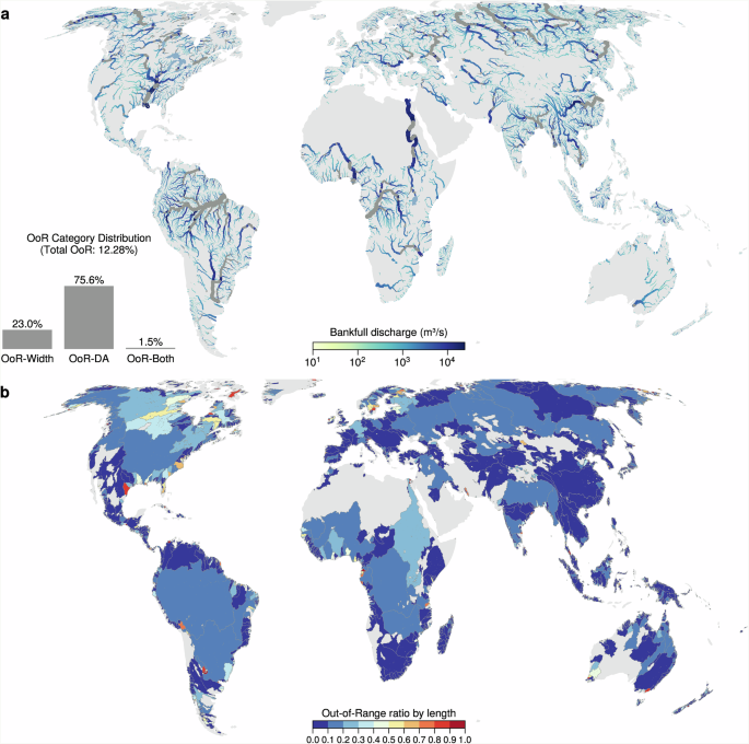
Bankfull discharge, the maximum flow a river can convey before spilling over its banks, is central to modelling flood risk and understanding river-channel evolution. Global flood inundation models assume a 2-year return period for bankfull conditions, but this assumption remains untested globally. Here we use observations and machine learning to estimate bankfull discharge at ~1-km resolution along a recently developed global river network. We show that the widely used 2-year discharge reasonably approximates bankfull-flow magnitude, but bankfull return periods vary substantially within and across climate zones. Bankfull conditions occur more frequently in tropical and temperate regions (median return periods of 1.5 and 1.8 years; interquartile ranges of 2.5 and 3.2 years, respectively) and less frequently in cold and arid regions (2.8 and 4.3 years; interquartile ranges of 4.8 and 6.0 years). This variation across climate zones provides a basis for improving the representation of channel capacity in global flood models.
Bridging the scale gap: enhancing point-scale rainfall estimates by post-processing ERA5
Authors: Fatima M. Pillosu, Timothy D. Hewson, Estíbaliz Gascón, Milana Vučković, Christel Prudhomme, Hannah Cloke
Journal: Bulletin of the American Meteorological Society · DOI: 10.1175/bams-d-25-0019.1
Matched topics: flood, climate change

Accurately estimating rainfall distributions, from-small-to-extreme totals, is crucial for addressing various environmental challenges (e.g., flood forecasting, water resource management, disaster preparedness). Global Numerical Weather Prediction (NWP) models can provide useful rainfall estimates; yet, they often misrepresent point-scale observations from rain gauges, underestimating the frequency of small rainfall totals and extreme values. In general, finer resolutions yield more accurate representation of gauge-based climatologies. Hence, this study provides a systematic, global verification of four NWP-modelled rainfall datasets of differing resolutions—ERA5’s Ensemble Data Assimilation (62 km, probabilistic), ERA5’s short-range forecasts (31 km, deterministic), short-range 46r1 ECMWF reforecasts (18 km, control run), and ERA5-ecPoint (point-scale, probabilistic)—against 20 years of global rain gauge observations, assessing each dataset’s ability to represent the entire rainfall distribution. Although in very mountainous areas (e.g., the Andes) ERA5-ecPoint underestimates zero-rainfall frequency and overestimates wet tail length, it dramatically improves upon raw NWP performance in many other regions by capturing more accurately the frequency of zeros, the “growth rates” of rainfall totals, and the wet tails. Moreover, due to its probabilistic nature, ERA5-ecPoint can estimate long return periods (e.g., 1000 years) without using distribution fitting, thereby offering valuable insights into extremely rare or unprecedented events at specific locations. Such findings underscore the importance of using post-processing to enhance the local-scale validity of global NWP models.
FEMA phase-out? Catastrophic extremes challenge decentralization of US flood insurance
Authors: Adam Nayak, Mengjie Zhang, Pierre Gentine, Upmanu Lall
Journal: Proceedings of the National Academy of Sciences · DOI: 10.1073/pnas.2537388123
Matched topics: river, flood
The U.S. National Flood Insurance Program (NFIP) faces growing solvency and affordability challenges amid proposals to decentralize the Federal Emergency Management Agency (FEMA) and shift disaster management to states. Catastrophic floods often span state boundaries, exposing multiple decentralized insurance pools simultaneously. Using a path-independent simulation framework that integrates risk-based premiums, hydrometeorologically clustered flood losses, and 2025 reinsurance contracts, we evaluate the stability of national and state-level pooling using historical data. National pooling markedly reduces systemic insolvency through cross-regional diversification, while many state pools exhibit structural fragility. State-level deficits are dominated by hyperclusters—coherent spatiotemporal losses induced by common atmospheric drivers—indicating that clustered loss governs failure. Since states must balance budgets and face borrowing restrictions to cover large losses, pool liquidity constrains decentralized systems. Existing reinsurance (including insurance-linked securities) does not always cover these clustered losses due to its misalignment with the clustered, spatiotemporal nature of hydroclimatic risk, covering only single flood events in traditional contracts and individual named storms in FloodSmart catastrophe bonds. A resilient and affordable NFIP will require hybrid financial design aligning risk-based premiums and reinsurance to balance chronic and catastrophic risk.
Insights from Ex-Typhoon Halong (2025) – An Arctic Cyclone of Tropical Origin
Authors: Mingshi Yang, Zhuo Wang, John E. Walsh, James D. Doyle, Richard L. Thoman, Alice K. DuVivier
Journal: Bulletin of the American Meteorological Society · DOI: 10.1175/bams-d-26-0004.1
Matched topics: flood
An Arctic cyclone, Ex-Typhoon Halong, produced strong winds and devastating flooding in southwestern Alaska during 11–12 October 2025. This study examines the evolution of Halong after its transition into an extratropical cyclone through the analysis of ERA5 reanalysis and simulations by the Weather Research and Forecasting (WRF) model. It is found that positive sea surface temperature (SST) anomalies over the western North Pacific preconditioned ex-Halong for intensification by increasing water vapor content and reducing static stability. Quasi-geostrophic lifting associated with a subsequent interaction with another extratropical cyclone led to the rapid deepening of ex-Halong. This case demonstrates that tropical cyclones can transition into extratropical systems that are intensified by anomalously warm ocean waters, exacerbating impacts in high latitudes. Further analyses indicate that an increasing fraction of Alaskan cyclones has originated in tropical latitudes (south of 30°N) in recent decades. In particular, the frequency of Arctic cyclones of tropical origin increased fourfold in August and threefold in September during 1980–2025 compared with 1940–1979.
Marine heatwaves and undernutrition in low- and middle-income countries
Authors: Clark Gray, Sally C. Dowd, Noah Shaul, Brian C. Thiede, Janet A. Nye
Journal: Proceedings of the National Academy of Sciences · DOI: 10.1073/pnas.2528506123
Matched topics: climate change, coastal, marine heatwave
Marine heatwaves are accelerating under climate change and increasingly threaten the lives and livelihoods of coastal populations, particularly in low- and middle-income countries where many households directly depend on local marine fisheries for protein, micronutrients, and income. To quantify this threat, we link individual-level data on child and maternal health from 9,813 coastal sites in 36 low- or middle-income countries to heatwave exposures in the nearby ocean, and use this linked dataset to estimate fixed-effects logistic regression models that test for heatwave effects on child mortality, wasting, and stunting, as well as adult underweight. We find that a 1 SD increase in the number of heatwaves over a 24-mo period increases the odds of child mortality by 5.4%, child wasting by 6.5% and child stunting by 8.8%, and that these effects also extend to other dimensions of heatwaves such as maximum sea surface temperature and cumulative intensity. Urban locations and countries more dependent on small-scale fishing are most strongly affected, and the majority of these results remain significant when we account for correlated atmospheric heatwaves. Taken together, these results document that marine heatwaves undermine human health and emphasize the need for additional research on the mechanisms connecting oceanic conditions to human health.
AI for Science
How AI is changing research
- Researchers presented 6000 papers at a major meeting. Could AI reproduce their findings? (Science, 2026-08-25) — Hackathon results suggest AI agents could make verifying research far more routine, potentially transforming how the scientific community checks reproducibility at scale.
Cross-discipline sparks
- To predict tree death, scientists tapped gamma rays to peer underground (Science, 2026-08-25) — Airborne gamma-ray radiometry — a technique already used in hydrology to map near-surface soil moisture — is now being extended to predict drought-driven tree mortality. The reverse cross-application is worth exploring: watershed-scale tree stress maps derived from operational gamma-ray soil-moisture flights could serve as a distributed biological proxy for subsurface drought intensity in data-sparse regions where ground-based monitoring is thin.
Statistics
| Metric | Count |
|---|---|
| Journals searched | 11 |
| Total papers fetched | 67 |
| Passed deterministic filter | 9 |
| After LLM relevance filtering | 5 |
| Rejected (not relevant) | 4 |
| AI for Science items picked | 2 |
Papers by journal
| Journal | Papers |
|---|---|
| Nature Communications | 1 |
| Bulletin of the American Meteorological Society | 2 |
| Proceedings of the National Academy of Sciences | 2 |
Filtering Criteria
Topics: river, flood, drought, reservoir, streamflow, runoff, watershed, basin, aquifer, groundwater, water resources, irrigation, hydropower, dam, levee, inundation, precipitation, rainfall, evapotranspiration, soil moisture, snowmelt, glacier, climate change, sea level, coastal, storm surge, estuary, wetland, remote sensing, satellite, machine learning, deep learning, neural network, data assimilation, land surface model, earth system model, hydrologic model, routing, water quality, sediment, erosion, geomorphology, paleohydrology, paleoclimate, Quaternary, Holocene, Pleistocene, fluvial, marine heatwave, ocean biogeochemistry
Fields: Earth and Planetary Sciences, Environmental Science, Geography, Atmospheric Science, Oceanography, Geochemistry and Petrology, Geology, Ecology