Paper Harvest Report
Date range: July 29, 2026
1 top-tier paper selected out of 128 total publications
Today’s Highlights
Today’s harvest surfaced one strong paper on flood monitoring: BayFlood, a new method that leverages the dense geographic coverage of dashboard cameras to detect floods at spatiotemporal granularities far beyond what satellites or stream gauges provide. The approach is particularly promising for equitable flood monitoring, as it can extend fine-grained coverage to communities underserved by conventional infrastructure. This has direct implications for real-time flood warning systems and post-event damage assessment in data-sparse regions.
Table of Contents
Top-Tier Journal Papers
Improving flood detection with large-scale dashboard camera data
Authors: Matt Franchi, Nikhil Garg, Wendy Ju, Emma Pierson
Journal: Nature Communications · DOI: 10.1038/s41467-026-75938-1
Matched topics: flood, remote sensing, machine learning
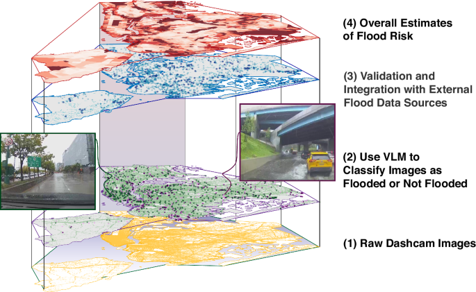
Flooding poses a significant and growing challenge globally, threatening infrastructure, livelihoods, and public safety. However, current methods for detecting floods are limited in their spatiotemporal granularity and inequitable in their coverage. Here, we propose BayFlood, a method for fine-grained flood detection that leverages dashboard camera data — a large-scale, widely distributed, and continuously updated source of visual information. By applying computer vision and Bayesian inference to dashboard camera footage, BayFlood can detect flood events at street-level resolution across broad geographic areas. Evaluations show that BayFlood substantially improves upon existing flood detection benchmarks, with particular gains in coverage of underserved communities that traditional monitoring systems disproportionately miss. The framework offers a scalable pathway to more equitable, high-resolution flood monitoring for disaster response and urban resilience planning.
Statistics
| Metric | Count |
|---|---|
| Journals searched | 11 |
| Total papers fetched | 128 |
| Passed deterministic filter | 4 |
| After LLM relevance filtering | 1 |
| Rejected (not relevant) | 3 |
| AI for Science items picked | 0 |
Papers by journal
| Journal | Papers |
|---|---|
| Nature Communications | 1 |
Filtering Criteria
Topics: flood, drought, streamflow, river, runoff, watershed, basin, precipitation, rainfall, evapotranspiration, groundwater, aquifer, irrigation, reservoir, dam, hydropower, water resources, hydrologic, hydraulic, water cycle, soil moisture, snowmelt, glacier, ice sheet, sea level, coastal, estuary, salinity, ocean, climate change, land surface, earth system model, remote sensing, satellite, machine learning, deep learning, neural network, Quaternary, paleoclimate, paleohydrology, fluvial, geomorphology, sediment, terrace, luminescence, OSL, Holocene, Pleistocene
Fields: Environmental Science, Earth and Planetary Sciences, Geography, Geology, Oceanography, Atmospheric Science, Engineering, Computer Science