Paper Harvest Report
Date range: August 19, 2026
3 top-tier papers selected out of 103 total publications
Today’s Highlights
Today’s papers reveal physical controls on water systems that most models still underestimate. In Antarctica, ocean-induced thinning and sea-ice loss—mechanisms largely absent from current ice-shelf models—are now recognized as primary collapse drivers, with significant consequences for sea-level projections and coastal risk. On land, bedrock lithology emerges as a geophysical constraint that flips expected drought-vulnerability patterns in forests: in karst terrain, younger and smaller trees are paradoxically the most vulnerable, contradicting the assumptions of most global drought frameworks. Bridging research and operations, the Argentina-Japan PREVENIR collaboration demonstrates how coupling Big Data Assimilation with numerical weather prediction and hydrological impact modeling can deliver actionable urban flood early warnings to vulnerable communities in South America.
Table of Contents
Top-Tier Journal Papers
PREVENIR: An Argentina-Japan Collaboration on Early Warning for Urban Floods
Authors: Takemasa Miyoshi, Yanina Garcia Skabar, Juan José Ruiz, Luciano Vidal, Shigenori Otsuka, Tomoo Ushio et al.
Journal: Bulletin of the American Meteorological Society · DOI: 10.1175/bams-d-25-0218.1
Matched topics: flood

The risk of heavy rain and urban flood disasters is rapidly increasing, posing an urgent global challenge, particularly with the escalating vulnerabilities of underprivileged populations. PREVENIR is a five-year (2022-2027) international cooperation project between Argentina and Japan. Its objective is to create an operational impact-based early warning system for urban floods and heavy rains in Argentina’s two most populated and susceptible regions. Leveraging cutting-edge research on Big Data Assimilation (BDA) with Japan’s flagship supercomputer “Fugaku” and its predecessor “K”, PREVENIR addresses three critical gaps: the transfer of advanced scientific research to practical operations, the integration of meteorological forecasting with hydrological impact modeling, and the effective communication of actionable warnings to emergency managers and the public. PREVENIR aims to develop a comprehensive disaster prevention package, encompassing monitoring, quantitative precipitation estimation (QPE), nowcasting, BDA and numerical weather prediction (NWP), hydrological model prediction, warning communications, public education and outreach, and capacity building. This extensive objective is being pursued through a collaborative effort. The Argentine National Meteorological Service and RIKEN (Japan’s premier scientific research institute) are spearheading this initiative, which also involves other academic research institutions and various levels of government and communities, both national and local. This pioneering endeavor in Argentina is expected to provide valuable tools and recommendations for the implementation of similar systems worldwide.
Reconsidering the drivers of ice-shelf collapse
Authors: J. F. Arthur, A. E. Hogg, B. W. J. Miles, C. C. Walker, B. J. Wallis
Journal: Nature Communications · DOI: 10.1038/s41467-026-76772-1
Matched topics: river

Antarctic ice shelves face increasing collapse risk as environmental stresses intensify. Long-term weakening, ocean-induced thinning, and loss of stabilizing sea ice can drive disintegration yet are mostly missing from models which only consider surface melt-driven fracturing, limiting accuracy of projections.
Bedrock lithology determines forest demographic responses to drought
Authors: Jiajia Su, Wuji Zheng, Xiaohua Gou, Janneke Hille Ris Lambers, Jan Altman, Yi Wang et al.
Journal: Nature Communications · DOI: 10.1038/s41467-026-76754-3
Matched topics: drought, surface water
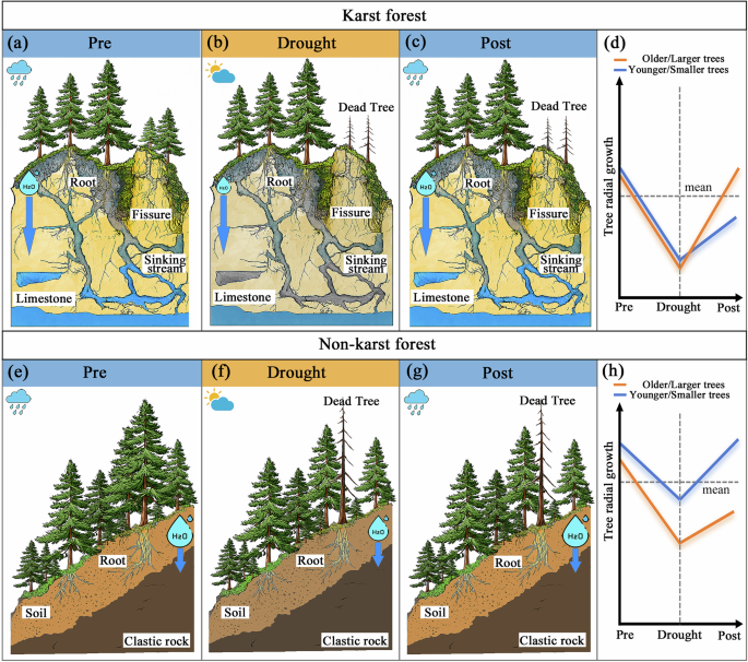
Forest vulnerability to drought depends not only on climate and traits, but also on bedrock controls on water dynamics, which remain poorly resolved. Here we integrate satellite-derived regolith water loss rate, a proxy for near-surface water retention capacity, with tree-ring records from 849 trees across 40 sites, carbon isotope measurements and mortality observations to examine forest demographic drought responses across karst and non-karst forests in southwest China. Bedrock lithology emerged as a key structural constraint on spatial variation in drought vulnerability, alongside climate, soil and trait variables. Notably, we identify a lithology-mediated inversion of demographic vulnerability: in karst forests, younger and smaller trees showed lower resistance and recovery than older and larger trees, especially under prolonged drought, whereas non-karst forests showed contrasting patterns. Site-level isotope and mortality evidence indicated physiological stress and growth decline consistent with this contrast, highlighting bedrock lithology as a geophysical constraint on forest demographic drought vulnerability. Drought threatens forests worldwide, but bedrock effects are overlooked. This study suggests that bedrock lithology reverses demographic drought responses in karst forests, leaving younger and smaller trees especially vulnerable to prolonged drought.
AI for Science
Cross-discipline sparks
- Video reconstruction of variable VLBI observations with neural fields (Nature, 2026-08-19) — Radio astronomers used implicit neural representations (neural fields) to reconstruct continuous images from sparse, irregularly sampled VLBI baselines — essentially learning a continuous function of space/time from incomplete observations. The same recipe is directly applicable to hydrological field reconstruction: a small earth-science team could train a neural field on a sparse stream-gauge or soil-moisture sensor network to produce spatially continuous, physically plausible field estimates — gap-filling where no sensor exists, in a way that classical kriging struggles with for highly nonstationary fields. The positional-encoding + MLP architecture is now off-the-shelf from NeRF literature; the barrier was always knowing the technique existed, not building it.
Statistics
| Metric | Count |
|---|---|
| Journals searched | 11 |
| Total papers fetched | 103 |
| Passed deterministic filter | 8 |
| After LLM relevance filtering | 3 |
| Rejected (not relevant) | 5 |
| AI for Science items picked | 1 |
Papers by journal
| Journal | Papers |
|---|---|
| Bulletin of the American Meteorological Society | 1 |
| Nature Communications | 2 |
Filtering Criteria
Topics: hydrology, hydrologic model, river, runoff, streamflow, reservoir, water management, flood, drought, seasonal, land surface model, climate change, hydropower, surface water, irrigation, earth system model, estuary, coastal, freshwater discharge, river plume, ocean biogeochemistry, marine heatwave, paleohydrology, paleoclimate, Quaternary, Holocene, Pleistocene, fluvial geomorphology, river terrace, loess, drainage network, river capture, landscape evolution, luminescence dating
Fields: engineering, environmental science, computer science, geology, geography