Paper Harvest Report
Date range: August 12, 2026
7 top-tier papers selected out of 115 total publications
Today’s Highlights
A landmark Nature study reconstructs 16 major floods across Europe in 1341–1343 — including four events with 500–1,000-year return periods — demonstrating that cascading megaflood sequences are a real feature of the climate system and that current risk management frameworks are dangerously unprepared for such multi-event extremes. In machine learning hydrology, a GRL study shows that geospatial foundation model embeddings from AlphaEarth and StefaLand can replace or augment traditional catchment attributes in deep learning rainfall-runoff models, achieving parity in gauged basins and meaningfully improving ungauged-basin predictions. A companion Nature paper publishes HydroGym, a reinforcement learning benchmark for fluid dynamics control problems that lowers the barrier for small earth-science teams to experiment with RL-based optimization of water system operations.
Table of Contents
- Today’s Highlights
- Top-Tier Journal Papers
- Cascading continental-scale floods across Europe in 1342–1343
- Geospatial Foundation Embeddings as Transferable Catchment Descriptors
- The Portrait of Flood Risk in Italy: Past, Present and Future, From 1870 to 2100
- Positive Association Between Coastal Sea Surface Temperatures and Humid Heat Stress on Nearby Land
- Dipole in North African Dust Deposition at the Last Glacial Maximum Explained by Shifted Wind Direction Under Steepened Meridional Temperature Gradients
- CROCUS Urban Canyons
- The HydroGym reinforcement learning platform for fluid dynamics
- AI for Science
- Statistics
- Filtering Criteria
Top-Tier Journal Papers
Cascading continental-scale floods across Europe in 1342–1343
Authors: Andrea Kiss, Alberto Viglione, Mariano Barriendos, Silvia Enzi, Martin Bauch, Kris Decker et al.
Journal: Nature · DOI: 10.1038/s41586-026-10888-8
Matched topics: flood
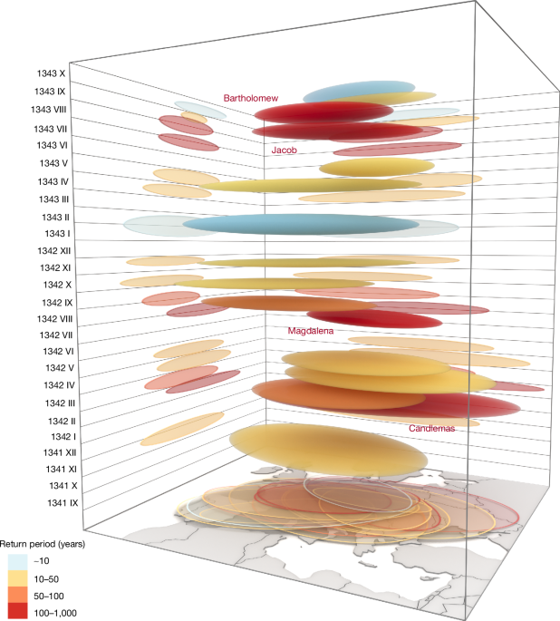
Europe has experienced extreme floods in recent decades. However, even larger floods are possible and must be considered in flood risk management. Their characteristics can be clarified by analysing the largest documented historical floods. In Central Europe, the Magdalena Flood of July 1342 is usually considered the largest of the last millennium; however, knowledge of its characteristics is incomplete. Here we show that 16 major flood events occurred across much of Europe between late 1341 and 1343. Four of these events had return periods of 500–1,000 years (the Magdalena, Bartholomew, Candlemas and Jacob Floods). Although Magdalena was thought previously to be the only extreme European flood in 1342, our new documentary dataset suggests that it formed part of a broader sequence. The year with the greatest number of extreme floods during the past 700 years was 1342, and 1343 ranks among the top ten. This highly unusual sequence of floods had substantial socio-economic impacts, including a paradigm shift in flood mitigation measures in Europe. A series of volcanic eruptions along with multi-annual Arctic sea ice retreat is a plausible cause of this flood sequence. Clusters of extreme floods occurring within a few months are rarely considered in risk management. Quick and proactive risk strategies are needed that account for this eventuality. Tracing cascading continental-scale medieval megafloods across Europe indicates that current flood management is unprepared for such sequences, highlighting the urgent need for proactive flood risk management strategies that account for unusual series of extreme flood events.
Geospatial Foundation Embeddings as Transferable Catchment Descriptors
Authors: Jiangtao Liu, Chaopeng Shen, Yuan Yang, Haoyu Ji, Kathryn Lawson, Nicholas Kraabel
Journal: Geophysical Research Letters · DOI: 10.1029/2026gl122814
Matched topics: runoff
Deep learning hydrological models rely on static catchment attributes to characterize basin heterogeneity, but these traditional descriptors suffer from regional inconsistency and limited temporal representativeness. This study evaluates geospatial foundation model embeddings (from AlphaEarth and StefaLand) as transferable catchment descriptors for rainfall‐runoff modeling. Temporal validation across 531 CAMELS basins showed that deep learning models trained on AlphaEarth embeddings alone achieved comparable performance to those trained on traditional attributes (median Nash‐Sutcliffe Efficiency (NSE) 0.779 vs. 0.781). In a global prediction in ungauged basins (PUB) scenario with 3,434 basins, combining embeddings with traditional attributes improved median NSE from 0.683 to 0.720. A dual‐path gated model revealed structured spatiotemporal reliance patterns: models preferentially utilized embeddings during snowmelt transitions and in humid basins, with limited reliance in arid catchments. Independent validation with StefaLand embeddings from a land‐surface foundation model yielded consistent temporal validation results, supporting the broader use of learned embeddings as transferable catchment descriptors.
The Portrait of Flood Risk in Italy: Past, Present and Future, From 1870 to 2100
Authors: Luciano Pavesi, Jose Luis Salinas, Stefano Zanardo, Maximiliano Sassi, Arno Hilberts, Elena Volpi et al.
Journal: Geophysical Research Letters · DOI: 10.1029/2026gl122987
Matched topics: river, flood, climate change
Among European countries, Italy ranks as one of the most susceptible to flood risk. While this figure is already substantial, climate change and rapid urbanization in flood‐prone areas have been identified as the two main drivers expected to elevate the number of individuals at risk. This study offers a comprehensive assessment of these two drivers of flood risk in Italy over 230 years, from 1870 to 2100, focusing on how they interact to increase risk. Using the large‐scale flood risk model RESCUE‐FR, we analyze the population at risk under the 200‐year return period scenario to provide a targeted assessment of population risk, how it has evolved in the past, and its projection in the future. Our findings indicate that while historical flood risk in Italy has primarily been influenced by population growth and migration into at‐risk areas, future projections suggest that climate change will become the dominant driver of flood risk.
Positive Association Between Coastal Sea Surface Temperatures and Humid Heat Stress on Nearby Land
Authors: Noel V. A. Siegert, Radley M. Horton
Journal: Geophysical Research Letters · DOI: 10.1029/2026gl122646
Matched topics: coastal, marine heatwave
Large populations along Earth’s coastlines are exposed to climate hazards including extreme humid heat. Considering observed coastal ocean warming and increased coastal marine heatwave (MHW) activity, we seek to uncover if, how, and where coastal ocean temperatures are linked with heat and humidity on land nearby. We analyze near‐coastal sea surface temperatures (SST) and corresponding land heat characteristics at 1,474 global coastal locations from 1990 to 2023 and find coastal MHW occurrence is associated with positive terrestrial heat/humidity anomalies across seasons, and that warmer coastal SST are associated with more frequent hot/humid extremes on land. We highlight an increase in concurrent marine and terrestrial (THW) heatwave days at many locations, which appears largely driven by MHW trends. Coastal MHW, THW, and concurrent events share similar buildup characteristics, but concurrent and MHW events are more humid than THW and display temperature anomalies which peak at the surface rather than aloft.
Dipole in North African Dust Deposition at the Last Glacial Maximum Explained by Shifted Wind Direction Under Steepened Meridional Temperature Gradients
Authors: Fangjingcheng Zhu, Peter O. Hopcroft, Samuel Albani, Minmin Fu, Anya J. Crocker, Chuang Xuan et al.
Journal: Geophysical Research Letters · DOI: 10.1029/2026gl121937
Matched topics: earth system model
Geological records strongly suggest that, globally, Earth’s atmosphere was much dustier than present during the Last Glacial Maximum (LGM) but the explanation is debated, with greater aridity, stronger/gustier winds and less effective washout from a drier atmosphere all invoked. Yet dust deposition can be spatially complex. Both the North Atlantic Ocean and Mediterranean Sea receive dust from the world’s main source, North Africa, but they suggest a dipole pattern of dust accumulation with increased and decreased LGM inputs respectively. Here we use pre‐industrial and LGM simulations from two Earth System models to investigate this dipole. We show that African dust export westwards to the Atlantic Ocean is favored by steep meridional North Atlantic thermal gradients and a strengthened Azores High while transport northwards to the Mediterranean is favored when temperature gradients and the Azores High are weaker. Our results show that wind direction can strongly influence paleo‐dust and ‐climate records.
CROCUS Urban Canyons
Authors: Scott Collis, Paytsar Muradyan, Robert Jackson, Bhupendra A. Raut, Joseph R. O’Brien, Matthew E. Tuftedal et al.
Journal: Bulletin of the American Meteorological Society · DOI: 10.1175/bams-d-24-0263.1
Matched topics: earth system model

CROCUS, a Department of Energy Integrated Urban Field Laboratory, sought to improve representation of urban earth system processes in earth system models, focusing on Chicago. One component of the CROCUS measurement strategy was a series of field campaigns. The first field campaign, conducted in July 2024, focused on the coupling of the urban fabric with the atmosphere of the Midwest and Great Lakes. The campaign aimed to study the urban heat island, but a climatologically unusual cool air mass settled in over the region, which led to a pivot in targeted science. CROCUS Urban Canyons launched 43 soundings from three sites and 17 windsondes designed to drift across the city to study boundary layer flows, including lake breezes. Additionally, the SPARC trailer was deployed at the edge of downtown Chicago, collecting an unprecedented multi-frequency LiDAR and radiometric dataset. A comprehensive suite of atmospheric chemistry measurements were conducted at the UIC campus, adjacent to and urban canyon selected to be the focus. The campaign also collected over 400 portable meteorological and air chemistry and particulate matter measurements during two two-day intensive observational periods. As CROCUS Urban Canyons was carried out in a megacity, community partnership, outreach and engagement were integral parts of the campaign, raising awareness of meteorological measurements across the city of Chicago and involving community members. This successful integration of scientific research and community engagement sets a strong foundation for future campaigns in the Chicago region.
The HydroGym reinforcement learning platform for fluid dynamics
Authors: Christian Lagemann, Sajeda Mokbel, Miro Gondrum, Mario Rüttgers, Yuning Wang, Pol Suárez et al.
Journal: Nature · DOI: 10.1038/s41586-026-10917-6
Matched topics: fluid dynamics, reinforcement learning
Abstract not available.
AI for Science
Cross-discipline sparks
- Computational ‘gym’ trains AI models to control turbulence (Nature, 2026-08-19) — Nature published HydroGym, a reinforcement learning benchmark specifically for fluid dynamics control problems (channel flow, bluff-body wake, cavity flow). For earth-science teams, this is a ready-made RL training harness that could be adapted directly to managed water systems — reservoir release optimization, irrigation canal gate control, or managed aquifer recharge scheduling — where the physics (Navier-Stokes at large scale) is the same challenge and a 1-2 person team could now attempt closed-loop control without building the environment from scratch.
Statistics
| Metric | Count |
|---|---|
| Journals searched | 11 |
| Total papers fetched | 115 |
| Passed deterministic filter | 16 |
| After LLM relevance filtering | 7 |
| Rejected (not relevant) | 10 |
| AI for Science items picked | 1 |
Papers by journal
| Journal | Papers |
|---|---|
| Nature | 2 |
| Geophysical Research Letters | 4 |
| Bulletin of the American Meteorological Society | 1 |
Filtering Criteria
Topics: hydrology, hydrologic model, river, runoff, streamflow, reservoir, water management, flood, drought, seasonal, land surface model, climate change, hydropower, surface water, irrigation, earth system model, estuary, coastal, freshwater discharge, river plume, ocean biogeochemistry, marine heatwave, paleohydrology, paleoclimate, Quaternary, Holocene, Pleistocene, fluvial geomorphology, river terrace, loess, drainage network, river capture, landscape evolution, luminescence dating
Fields: engineering, environmental science, computer science, geology, geography