Paper Harvest Report
Date range: July 30, 2026
7 top-tier papers selected out of 119 total publications
Today’s Highlights
A study in Nature Geoscience finds that compound atmospheric–riverine heatwaves across 796 river basins have tripled since the 1980s, with the sharpest acceleration in high-elevation mountain rivers; by 2100, nearly all riverine heatwaves are projected to co-occur with atmospheric heatwaves under high emissions. Three papers advance tropical cyclone intensity forecasting using machine learning, with a coupled atmosphere-ocean-wave model achieving 90% detection of rapid intensification in the Northwest Pacific — far exceeding existing operational models. Rounding out the day, an explainable-AI study maps the time-varying hydroclimatic controls on Arctic submarine groundwater discharge, and a GRL study improves the representation of surface emissivity in the Energy Exascale Earth System Model (E3SM).
Table of Contents
- Today’s Highlights
- Top-Tier Journal Papers
- Threefold increase in atmospheric–riverine compound heatwaves under climate change
- Greenhouse warming exacerbates El Niño-induced Indian monsoon droughts
- Time‐Varying Hydroclimatic and Oceanic Controls on Arctic Submarine Groundwater Discharge Inferred Using Explainable AI
- Improved Representation of Surface Emissivity Effects on Longwave Radiation in a Coupled Earth System Model
- Benchmark dataset and deep learning method for global tropical cyclone forecasting
- Forecasts of strong tropical cyclones improved by incorporating ocean waves at air–sea interface
- Beyond a single rapid intensification threshold: a continuous intensification rate index for tropical cyclones using vortex-scale machine learning
- AI for Science
- Statistics
- Filtering Criteria
Top-Tier Journal Papers
Threefold increase in atmospheric–riverine compound heatwaves under climate change
Authors: Yu Zhou, Yanxia Shen, Wei Zhi, Bo Zhou, Senlin Zhu, Li Yuan et al.
Journal: Nature Geoscience · DOI: 10.1038/s41561-026-02040-y
Matched topics: river, climate change
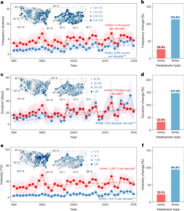
Record-breaking heatwaves disrupt global water, energy and food systems, yet the co-occurrence of atmospheric and riverine events remains largely unexplored. Here we analyse 796 river basins in the USA and Central Europe to characterize such co-occurring atmospheric–riverine compound heatwaves. Combining water quality observations with a deep learning model, we find that compound heatwaves have increased by about 0.40 events per decade since the 1980s. This corresponds to a rise from roughly 0.76 events per year in the early period to about three times that frequency today, meaning their occurrence has effectively tripled over the past four decades. This trend coincides with the rapid intensification of riverine heatwaves, which have increased in frequency (114%), duration (148%) and intensity (95%) between 1981–1990 and 2010–2019, far outpacing changes in atmospheric heatwaves. Compound occurrences are primarily controlled by climatic (59.2%), topographic (22.4%) and hydrological (18.3%) factors, with amplified trends in high-elevation (>3,000 m) mountain rivers (+128% per decade). Compared with isolated riverine heatwaves, compound heatwaves drive an additional 16% rise in water temperature and a further 2.9% decline in dissolved oxygen. Under a high-emissions scenario, 98.5% of riverine heatwaves will coincide with atmospheric heatwaves by 2100. These findings highlight the escalating threats of compound heatwaves to freshwater ecosystems and the need to incorporate their dynamics into future water risk assessments.
Greenhouse warming exacerbates El Niño-induced Indian monsoon droughts
Authors: Yutong Zhao, Tao Wang, Chaoyi Xu, Xichen Li, Shilong Piao, Tandong Yao
Journal: Nature Communications · DOI: 10.1038/s41467-026-76049-7
Matched topics: drought

The inverse relationship between the El Niño‒Southern Oscillation (ENSO) and the Indian summer monsoon has weakened since the early 1980s. Here, we demonstrate that the historical weakening of the ENSO–monsoon relationship was caused by two unusual events (in 1983 and 1997), and greenhouse warming has actually strengthened rather than weakened this link between 1902 and 2023 and is projected to continue doing so. However, confidence in the projection of this enhancement remains relatively low. We attribute the model spread in ENSO–monsoon links to variations in ENSO-induced Walker circulation anomalies, primarily through zonal wind feedback processes. Through the use of multiple observations to constrain such atmospheric dynamic processes, we find that the observation-constrained sensitivity of monsoons to the ENSO by the end of this century will become almost 40% greater than that from 1963–2023. Such intensification occurs because, even if the degree of El Niño-induced sea surface warming remains unchanged, the response of tropical precipitation to sea surface warming will increase, causing further eastward displacement of Walker circulation anomalies and an increased subsidence over the Indian subcontinent, which will reduce monsoon precipitation further. Our findings suggest intensified hydrological extremes and increased risks for food security in India in a warmer future.
Time‐Varying Hydroclimatic and Oceanic Controls on Arctic Submarine Groundwater Discharge Inferred Using Explainable AI
Authors: Cansu Demir, Jesus D. Gomez‐Velez, Julia Guimond, James W. McClelland, Matthew A. Charette, M. Bayani Cardenas
Journal: Geophysical Research Letters · DOI: 10.1029/2026gl123641
Matched topics: river, seasonal, coastal
Submarine groundwater discharge (SGD), an important component of coastal water and nutrient budgets, is challenging to monitor and predict in the Arctic given the remoteness and harsh conditions. Here, we used explainable artificial intelligence to quantify the time‐varying importance of hydroclimatic and oceanic drivers of SGD at an Arctic beach from the early thaw period to late summer. Deep learning models were trained on in situ observations and reanalysis data, and feature contributions to model prediction were quantified using SHAP (Shapley Additive Explanations). We learned the following: potential evaporation is the dominant control on groundwater storage and SGD over seasonal scales; winds regulate short‐term groundwater levels and intermediate‐term discharge; soil temperature modulates groundwater storage via thaw‐driven processes; and precipitation is important for short‐term groundwater flushing and seasonal‐scale storage. These insights on the scale‐dependent SGD controls establish a framework for hindcasting and forecasting groundwater dynamics in remote Arctic environments.
Improved Representation of Surface Emissivity Effects on Longwave Radiation in a Coupled Earth System Model
Authors: Lili Manzo, Charles S. Zender, Erin E. Thomas, Andrew Roberts
Journal: Geophysical Research Letters · DOI: 10.1029/2025gl120504
Matched topics: earth system model
Many Earth System Models (ESMs) approximate surface emissivity as constant over all wavelengths (broadband). This approximation misrepresents the spectral distribution of longwave (LW) flux and introduces error in the LW atmospheric heating rate. Many ESMs employ the “Effective Greybody” (EG) method, which creates bias in the effective temperature used by the atmosphere component. We implement a novel “Full Greybody” (FG) method, modifying the treatment of LW flux in the atmosphere to match that of the ocean surface component in the Energy Exascale Earth System model. We find that, relative to greybody emissivity, the ocean blackbody approximation over the ocean overestimates instantaneous mean upwelling LW surface flux by 1.38±0.05 W/m². The common EG method introduces a mean bias of −0.24 K in the effective temperature. The FG method reduces this bias to 0.0039 K, comparable to the default blackbody bias (0.0070 K) while making ocean emission in ESMs more physically realistic.
Benchmark dataset and deep learning method for global tropical cyclone forecasting
Authors: Cheng Huang, Pan Mu, Jinglin Zhang, Sixian Chan, Shiqi Zhang, Hanting Yan et al.
Journal: Nature Communications · DOI: 10.1038/s41467-025-61087-4
Matched topics: machine learning, flood, coastal
Accurate tropical cyclone (TC) forecasting is critical for disaster prevention. While deep learning shows promise in weather prediction, existing approaches demonstrate limited accuracy in TC track and intensity forecasting, hindered by the lack of open multimodal datasets and insufficient integration of meteorological knowledge. Here we propose TropiCycloneNet containing TCND — an open multimodal TC dataset spanning six major ocean basins with 70 years of multi-source data, and TCNM — an AI-meteorology integrated prediction model including multiple modules such as Generator Chooser Network and Environment-Time Net. Comprehensive evaluations demonstrate that TCNM outperforms both existing deep learning methods and official meteorological forecasts across multiple metrics. This advancement stems from synergistic optimization of our meteorologically-informed architecture and the dataset’s comprehensive spatiotemporal coverage. The released resources and method can attract more researchers to the field, thereby accelerating data-driven tropical cyclone prediction research.
Cited in today’s Nature article on operational AI tropical cyclone forecasting.
Forecasts of strong tropical cyclones improved by incorporating ocean waves at air–sea interface
Authors: Songlin Li, Biao Zhao, Qi Shu, Vladimir Ryabinin, Dong Ji, Guomin Chen et al.
Journal: Communications Earth & Environment · DOI: 10.1038/s43247-026-03754-y
Matched topics: coastal, river routing, flood
Tropical cyclones, also known as typhoons or hurricanes, pose grave threats to coastal populations. Advances in remote sensing and increasing computing power over recent decades have led to marked improvement in track forecasting. However, a cyclone’s destructive power depends on its intensity. Yet operational forecasts continue to severely underpredict the peak intensity of strong cyclones, while overpredicting weak ones. Current forecasting models include the atmosphere–ocean coupling but ignore the sizable energy and momentum transfers from the ocean by breaking waves, and the modulation of mixed-layer depths by non-breaking surface waves. Here we demonstrate using operational data that accounting for the dynamic air–sea interface in a numerical regional model improves the forecast of tropical cyclone intensities. Probability of detection for rapid intensification in the Northwest Pacific increases to 90% compared to 10–50% from existing models. A long-awaited breakthrough in predictions of tropical cyclone intensity, especially for strong ones, becomes achievable.
Cited in today’s Nature article on operational AI tropical cyclone forecasting.
Beyond a single rapid intensification threshold: a continuous intensification rate index for tropical cyclones using vortex-scale machine learning
Authors: Cheng-Hsiang Chih, Chun-Chieh Wu, Yi-Hsuan Huang
Journal: npj Climate and Atmospheric Science · DOI: 10.1038/s41612-026-01478-6
Matched topics: machine learning, flood
The rapid intensification (RI) of tropical cyclones (TCs) remains one of the most persistent challenges in operational forecasting, particularly in the western North Pacific (WNP), where RI events are most frequent and intense globally. Although numerical weather prediction continues to advance, adaptive tools are needed to resolve the multi-scale processes driving sudden intensity changes. Existing studies often rely on static binary thresholds for RI occurrence. However, the physical mechanisms favoring RI emerge at varying stages during the intensification process across different cases, governed by concurrent environmental conditions and internal vortex dynamics rather than any fixed RI definition. To address these limitations, this study establishes a diagnostic system for TC intensification in the WNP by integrating vortex-scale reanalysis data for capturing structural drivers of RI, a new continuous intensification rate (IR) index that moves beyond traditional binary RI classifications, and machine learning techniques. Following systematic hyperparameter optimization, the Random Forest, Support Vector Regression, and Artificial Neural Network models all demonstrated consistent and reliable performance in linking higher IR index values to increased probabilities of TC intensification.
Cited in today’s Nature article on operational AI tropical cyclone forecasting.
AI for Science
How AI is changing research
-
Operational Tropical Cyclone Forecasting with AI (Nature, 2026-08-06) — A Nature research paper demonstrates that AI can now perform operational-grade tropical cyclone track and intensity forecasting, matching or outperforming numerical weather prediction. For hydrologists, this represents a step-change: AI-based cyclone forecasts feed directly into flood inundation models and reservoir pre-release decisions, and the same architecture could be adapted for atmospheric-river or extreme-precipitation nowcasting.
-
AI agents are checking the scientific literature — and spotting decades-old errors (Nature, 2026-08-06) — AI agents are now autonomously scanning published literature and reference databases to flag errors that human reviewers missed for decades. For hydrology research groups, this is immediately actionable: automated agents could audit the ratings curves, stream-gauge datasets, and model validation benchmarks that underpin decades of river-routing and flood-frequency analysis.
Statistics
| Metric | Count |
|---|---|
| Journals searched | 11 |
| Total papers fetched | 119 |
| Passed deterministic filter | 11 |
| After LLM relevance filtering | 7 |
| Rejected (not relevant) | 7 |
| AI for Science items picked | 2 |
Papers by journal
| Journal | Papers |
|---|---|
| Nature Geoscience | 1 |
| Nature Communications | 2 |
| Geophysical Research Letters | 2 |
| Communications Earth & Environment | 1 |
| npj Climate and Atmospheric Science | 1 |
Filtering Criteria
Topics: hydrology, hydrologic, streamflow, river, runoff, flood, drought, reservoir, dam, irrigation, groundwater, aquifer, water quality, watershed, basin, precipitation, rainfall, snowmelt, evapotranspiration, land surface, soil moisture, water resources, water cycle, climate change, sea level, coastal, estuary, ocean, salinity, nutrient, carbon, erosion, sediment, geomorphology, paleoclimate, Quaternary, Holocene, Pleistocene, earth system model, ESM, CESM, E3SM, MOSART, ELM, remote sensing, machine learning, deep learning, neural network, seasonal, seasonal prediction
Fields: Environmental Science, Geography, Earth and Planetary Sciences, Geology, Oceanography, Atmospheric Science, Hydrology, Civil Engineering, Agricultural and Biological Sciences