Paper Harvest Report
Date range: September 24, 2026
7 top-tier papers selected out of 14 total publications passing deterministic filters (117 fetched)
Today’s Highlights
This harvest captures how extreme hydrometeorological events reshape both terrestrial and marine systems. SWOT satellite data (Science) reveals the pervasive human imprint on rivers worldwide while exposing gaps in flood prediction models—a direct challenge to the modeling community. Three GRL studies extend the picture downstream and offshore: a single typhoon can reorganize mountain watershed groundwater for months, North Sea storm surges are amplified when storms cluster days apart, and freshwater discharge from extreme precipitation can drive biogeochemical anomalies hundreds of kilometers into the open ocean. Nature Communications rounds out the day with evidence that tropical cyclone post-landfall decay follows divergent intensity-dependent trends, and that incomplete barrier-island recovery after extreme storms may be quietly increasing future flood vulnerability.
Table of Contents
- Today’s Highlights
- Top-Tier Journal Papers
- Satellite reveals a world of altered rivers
- Typhoon‐Driven Near‐Surface Groundwater Dynamics Revealed by Ambient Noise in the Mountain Watershed
- North Sea Storm Surges Amplified by Oscillations Triggered by Preceding Storms
- Open Ocean Biogeochemical Impacts of Extreme Terrestrial Precipitation
- Advancing Operational Flood Inundation Maps Through Usability Testing of NOAA’s Flood Inundation Maps
- Barrier island geomorphic complexity drives storm and post-storm response
- Divergent trends in post-landfall decay of strong and weak tropical cyclones
- Statistics
- Filtering Criteria
Top-Tier Journal Papers
Satellite reveals a world of altered rivers
Authors: Paul Voosen
Journal: Science · DOI: 10.1126/science.aem6543
Matched topics: river, flood
SWOT is exposing how humans reshape rivers—and challenging models used to predict floods.
Typhoon‐Driven Near‐Surface Groundwater Dynamics Revealed by Ambient Noise in the Mountain Watershed
Authors: Cheng‐Hua Tsai, Luc Illien, Li‐Wei Chen, Ci‐Jian Yang
Journal: Geophysical Research Letters · DOI: 10.1029/2026gl124584
Matched topics: surface water
Near‐surface groundwater dynamics (NSGD) regulate water residence time and downstream water resources in mountain watersheds, yet whether a single extreme rainfall event can reorganize near‐surface storage remains unclear. Here, we examine typhoon‐driven NSGD using ambient seismic noise from four stations, together with hydrological and meteorological records. Single‐station cross‐component correlations and the stretching method were applied to estimate seismic velocity changes (dυ/υ) at 4–8 Hz. Following the typhoon, dυ/υ has spatial variability, ranging from ∼10 days upstream to at least 3 months downstream. We attribute this delayed recovery to thicker colluvium and fractured bedrock that enhance subsurface water retention. Concurrent decreases in dυ/υ and increases in groundwater levels indicate transient vertical coupling between shallow and deeper systems. Continued post‐typhoon dυ/υ decreases suggest delayed lateral inflow from upstream, whereas later low‐intensity rainfall responses indicate subsequent decoupling. Our results show that a single typhoon prolonged watershed scale NSGD with insight for water residence time in mountainous regions.
North Sea Storm Surges Amplified by Oscillations Triggered by Preceding Storms
Authors: Joris G. W. Beemster, Rijk A. Landsmeer, Sander A. M. A. de Maat, Chris B. M. Weijenborg, Svenja Fischer, Dirk S. van Maren et al.
Journal: Geophysical Research Letters · DOI: 10.1029/2026gl125098
Matched topics: flood, coastal
Storm surges are often treated as independent extremes, yet extratropical cyclones and associated coastal water‐level extremes frequently occur in clustered sequences. Although clustering can increase flood hazard by shortening recovery time, it remains unclear whether preceding storms amplify subsequent surges. We investigate this for the North Sea along the NW European Shelf using long‐term tide gauge records and idealized hydrodynamic modeling. Observations show a pronounced excess of surge events separated by 1–3 days; events occurring about 2 days after a preceding surge have median peak heights 17.5% (6.8 cm) higher than more isolated events. Sequential‐storm experiments reproduce this timing dependence. Amplification arises from lingering post‐surge basin oscillations that constructively interact with subsequent storms, while nonlinear tide–surge interactions modulate but do not remove the effect. Storm clustering can therefore influence not only the frequency, but also the magnitude, of extreme coastal water levels.
Open Ocean Biogeochemical Impacts of Extreme Terrestrial Precipitation
Authors: Shailja Gangrade, Mara A. Freilich, Élise Beaudin, Kelly M. A. Luis, Inés M. Leyba, Melissa M. Omand et al.
Journal: Geophysical Research Letters · DOI: 10.1029/2026gl122966
Matched topics: river, flood, freshwater discharge
Extreme events reshape ocean ecosystems with significant implications for nutrient and carbon cycling. Here, we demonstrate that flooding on land can be a significant driver of biogeochemical variability in the open ocean, even in relatively dry climates. Using satellite observations, in situ measurements, and Lagrangian particle tracking, we present evidence that freshwater discharge from extreme precipitation during the 2023 water year was transported into the oligotrophic region of the California Current System. This transport was facilitated by submesoscale eddies and filaments and resulted in significant anomalies in surface salinity, stratification, nutrient concentrations, as well as phytoplankton and bacterioplankton community composition. These observations highlight the importance of episodic river discharge events in shaping offshore biogeochemical fluxes and ecosystem structure in eastern boundary current systems. With more frequent atmospheric river events projected, the likelihood of observing these specific hydrographic and biogeochemical conditions may be increasing.
Advancing Operational Flood Inundation Maps Through Usability Testing of NOAA’s Flood Inundation Maps
Authors: Sajani Kandel, Snehalata Sainjoo, Apoorva Joshi, David Vallee, Derek Giardino, Jeff Dobur et al.
Journal: Bulletin of the American Meteorological Society · DOI: 10.1175/bams-d-25-0228.1
Matched topics: river, flood

Forecast decision support products play a vital role in translating complex hazard information into formats that support time-critical decisions. To support accurate interpretation, these products must be grounded in empirically tested evidence from multidisciplinary research. The goal of this study is to improve the usability of NOAA’s experimental Flood Inundation Map (FIM) services by identifying usability challenges and empirically evaluating how targeted design changes affect user understanding and interpretation. An online survey experiment (n = 1,054) assessed the effects of alternative FIM product layer descriptions and legends on understandability, measured through interpretation accuracy and perceived clarity. Most participants did not correctly associate colors with their intended flood stage categories, revealing key issues in flood risk communication. Redesigned legends significantly improved both interpretation accuracy and perceived clarity. Numeracy and geospatial experience were the strongest predictors of accuracy, highlighting that current FIM service designs may implicitly favor users with higher technical skills.
Barrier island geomorphic complexity drives storm and post-storm response
Authors: Jennifer L. Miselis, Noreen A. Buster, Daniel J. Ciarletta, Julie C. Bernier, Emily A. Wei, Rose V. Palermo
Journal: Nature Communications · DOI: 10.1038/s41467-026-77143-6
Matched topics: river, climate change
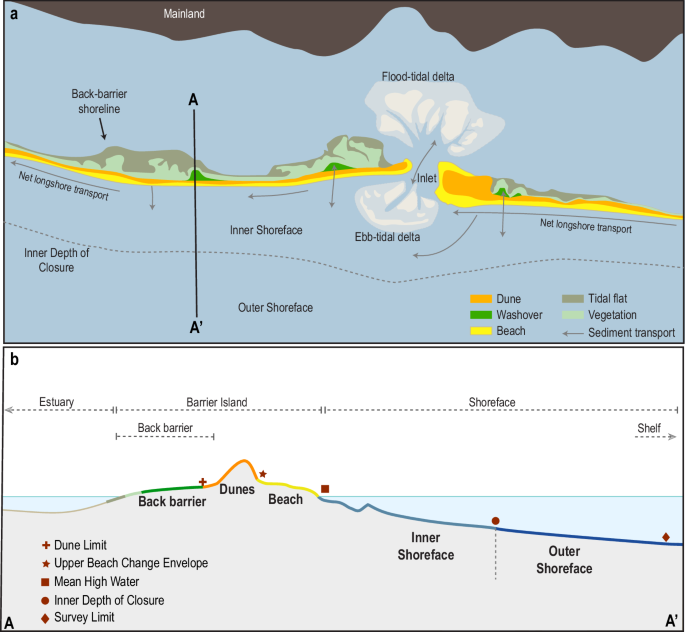
Barrier islands are at the forefront of climate-driven changes, with their resiliency threatened by rapid fluctuations in the physical drivers that shape them. Quantifying magnitudes and directions of storm-driven sediment fluxes and rates and modes of sediment recovery is essential for predicting barrier island trajectories. Yet scarce shoreface observations have limited such efforts. Here, shoreface-inclusive measurements of barrier sediment fluxes over five years following an extreme storm reveal distinct sediment redistribution patterns that vary with island geomorphology. Overwash fluxes were low compared with seaward fluxes, inlet-related landward transport, and previously modeled estimates. Without these observations, models may overestimate island elevation-building capacity that is key to sea-level adaptability. Post-storm recovery was incomplete despite human intervention, altering barrier sediment distribution from pre-storm conditions. This may increase vulnerability to future storms and rising water levels and suggests management approaches tailored to island geometry may better compete with climate change effects.
Divergent trends in post-landfall decay of strong and weak tropical cyclones
Authors: Chenxi Hu, Xinxin Sui, Dev Niyogi, Clint N. Dawson, Zong-Liang Yang
Journal: Nature Communications · DOI: 10.1038/s41467-026-77958-3
Matched topics: coastal

Tropical cyclone post-landfall decay strongly influences inland hazard exposure, yet most studies assume that environmental change affects storms of different intensities uniformly. Here we identify an intensity-dependent divergence in global trends of tropical cyclone post-landfall decay. Analyzing 885 observed events (1979–2024), we show that strong storms (≥29 m/s) now weaken 18.6% faster after landfall, whereas weak storms persist 14.5% longer inland. These contrasting trends arise from different environmental sensitivities. Weak storms respond primarily to thermodynamic factors, including sea-surface warming, enhanced atmospheric moisture, and increased oceanic influence along storm tracks, all of which favor prolonged inland persistence. In contrast, strong storms are more sensitive to dynamic and land-surface conditions, including faster translation speeds, increasing atmospheric stability, and drier soil, which collectively promote faster decay. These results challenge uniform-response assumptions in tropical cyclone risk assessment, forging a dual-threat landscape: intensifying coastal impacts from faster-decaying strong storms alongside expanding inland risks from increasingly persistent weak systems.
Statistics
| Metric | Count |
|---|---|
| Journals searched | 11 |
| Total papers fetched | 117 |
| Passed deterministic filter | 14 |
| After LLM relevance filtering | 7 |
| Rejected (not relevant) | 7 |
| AI for Science items picked | 0 |
Papers by journal
| Journal | Papers |
|---|---|
| Science | 1 |
| Geophysical Research Letters | 3 |
| Bulletin of the American Meteorological Society | 1 |
| Nature Communications | 2 |
Filtering Criteria
Topics: hydrology, hydrologic model, river, runoff, streamflow, reservoir, water management, flood, drought, seasonal, land surface model, climate change, hydropower, surface water, irrigation, earth system model, estuary, coastal, freshwater discharge, river plume, ocean biogeochemistry, marine heatwave, paleohydrology, paleoclimate, Quaternary, Holocene, Pleistocene, fluvial geomorphology, river terrace, loess, drainage network, river capture, landscape evolution, luminescence dating
Fields: engineering, environmental science, computer science, geology, geography