Paper Harvest Report
Date range: July 28, 2026
2 top-tier papers selected out of 103 total publications
Today’s Highlights
Today’s two papers illuminate the underappreciated predictability of coastal dynamics. A study in Nature Communications demonstrates that tidal-dominated coastal floods recur at highly consistent times of day—Boston experiences peak events near noon and midnight while Southern California floods in the morning—due to phase-locking of tidal constituents with the solar day, opening new avenues for targeted emergency planning and risk communication. A companion study in Geophysical Research Letters uses NASA’s SWOT satellite to directly quantify rapid intertidal sediment changes in the Ganges-Brahmaputra delta’s Meghna Estuary, documenting a net 70 Megatonne sediment flux over just one year and demonstrating SWOT’s power for monitoring dynamic coastlines worldwide.
Table of Contents
Top-Tier Journal Papers
Rapid Morphological Changes in the Intertidal Zone of the Ganges‐Brahmaputra Delta Revealed by SWOT Altimetry Mission
Authors: Nushrat Yeasmin, Laurent Testut, Valérie Ballu, Md Jamal Uddin Khan
Journal: Geophysical Research Letters · DOI: 10.1029/2026gl122592
Matched topics: hydrology, surface water, estuary, coastal
Intertidal zones of the Ganges‐Brahmaputra (GB) delta are among the most active coastal environments worldwide, and quantifying their morphological evolution remains challenging due to rapid change and scarce in situ observations. This study presents a satellite‐based direct quantification of intertidal sediment volume change in the Meghna Estuary of the GB delta using the Surface Water and Ocean Topography (SWOT) altimetry mission. Originally designed to observe fine‐scale ocean dynamics and inland hydrology, SWOT also allows accurate mapping of intertidal topography. Using SWOT‐based intertidal topography, this study assesses elevation change and associated sediment erosion and accretion volume over a 1‐year interval (2024–2025). The analysis reveals a net sediment change of 70.32 ± 0.12 Megatonnes with distinct island‐scale and local‐scale sediment redistribution patterns. Consistent spatial patterns observed from overlapping different SWOT passes support the robustness of the derived changes, demonstrating a powerful approach for monitoring rapidly evolving intertidal changes across the world’s coastline.
Coastal flooding at predictable hours
Authors: Joris G. W. Beemster, Stefan A. Talke, Ivan D. Haigh, Ben S. Hague, Grace C. Levins, Dirk S. van Maren
Journal: Nature Communications · DOI: 10.1038/s41467-026-75710-5
Matched topics: flood, coastal
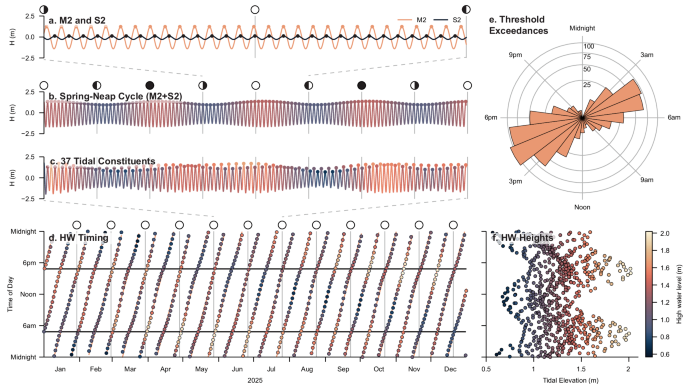
Flooding is typically perceived as a sudden and unpredictable hazard. Here, we show that recurrent flooding can occur at highly predictable times in tidally dominated coastal systems. This predictability stems from phase-locking of tidal constituents and constituent pairs with the solar day, causing peak tides to recur at consistent local times set by regional tidal propagation. Using tide-gauge records from the United States and the United Kingdom, we quantify the intraday timing of coastal flood events and show strong clustering at specific hours, particularly where semidiurnal or mixed tides dominate. For example, floods in Boston cluster around noon and midnight, whereas in southern California they occur in the morning. Sites with stronger non-tidal variability show weaker clustering. This temporal predictability extends beyond nuisance flooding to larger consequential events involving inundation, road closures and infrastructural damage, highlighting opportunities for anticipatory risk communication, emergency planning and time-sensitive coastal adaptation. The study shows that coastal floods in tide-dominated regions often occur at predictable hours, enabling more targeted warnings, emergency planning, and time-sensitive adaptation.
Statistics
| Metric | Count |
|---|---|
| Journals searched | 11 |
| Total papers fetched | 103 |
| Passed deterministic filter | 5 |
| After LLM relevance filtering | 2 |
| Rejected (not relevant) | 3 |
| AI for Science items picked | 0 |
Papers by journal
| Journal | Papers |
|---|---|
| Geophysical Research Letters | 1 |
| Nature Communications | 1 |
Filtering Criteria
Topics: hydrology, hydrologic model, river, runoff, streamflow, reservoir, water management, flood, drought, seasonal, land surface model, climate change, hydropower, surface water, irrigation, earth system model, estuary, coastal, freshwater discharge, river plume, ocean biogeochemistry, marine heatwave, paleohydrology, paleoclimate, Quaternary, Holocene, Pleistocene, fluvial geomorphology, river terrace, loess, drainage network, river capture, landscape evolution, luminescence dating
Fields: engineering, environmental science, computer science, geology, geography