Paper Harvest Report
Date range: September 03, 2026
6 top-tier papers selected out of 114 total publications
Today’s Highlights
A Nature Communications study finds that nearly one-third of global droughts are followed by abrupt transitions to extreme precipitation, with antecedent drought development characteristics — intensity, rate, and duration of soil-moisture decline — shaping distinct land–atmosphere feedback pathways to compound hydroclimatic extremes. Using NASA’s SWOT satellite, researchers deployed the SWOT-FLASH framework to resolve spatial surface gradients across Poyang Lake (China’s largest floodplain lake), estimating a massive seasonal buffering capacity of 22.71 ± 1.96 km³, accounting for 95% of total lake storage variation — a physically realistic tool now applicable to complex river–floodplain systems worldwide. Meanwhile, scientists traced the devastating 2024 Tibet–Nepal flood to a massive landslide cascade, demonstrating how global cooperation in post-event analysis can illuminate the chain of triggers behind extreme flood disasters.
Table of Contents
- Today’s Highlights
- Top-Tier Journal Papers
- How scientists unraveled the causes of the devastating flood in Tibet and Nepal
- How Much Water Can Be Seasonally Buffered by China’s Largest Floodplain Lake? A Refined Estimate From SWOT
- Drought development characteristics modulate global dry–wet abrupt alternation through distinct land–atmosphere feedbacks
- Paleogeographic controls on Phanerozoic weathering rates and implications for climate regulation
- Decision Calendars for Cold Regions Hydrological Forecasting: Collaboration in the Transboundary Yukon River Basin
- Precipitation and soil phosphorus regulate post-drought resilience in tropical forests
- AI for Science
- Statistics
- Filtering Criteria
Top-Tier Journal Papers
How scientists unraveled the causes of the devastating flood in Tibet and Nepal
Authors: Hannah Richter
Journal: Science · DOI: 10.1126/science.aem0437
Matched topics: flood
Global cooperation revealed a huge landslide likely initiated the cascade of events.
How Much Water Can Be Seasonally Buffered by China’s Largest Floodplain Lake? A Refined Estimate From SWOT
Authors: Lingyang Liu, Kai Liu, Jida Wang, Tan Chen, Pengfei Zhan, Yi Peng et al.
Journal: Geophysical Research Letters · DOI: 10.1029/2026gl125367
Matched topics: hydrology, river, flood, seasonal
Poyang Lake, China’s largest floodplain lake, plays a crucial role in regional hydrology by seasonally regulating water to mitigate floods and sustain extensive wetland ecosystems. However, complex hydrodynamics and significant spatial hydraulic gradients often invalidate the traditional “flat‐water” assumption, making reliable estimation of the lake’s true seasonal buffering capacity a persistent challenge. To address this, we developed a SWOT‐based Floodplain Lake wAter volume and Storage cHange (SWOT‐FLASH) framework. By integrating two‐dimensional water surface elevations from the SWOT mission with reconstructed full‐lake bathymetry, this method explicitly resolves spatial surface gradients to estimate a massive seasonal buffering capacity of 22.71 ± 1.96 km³ for Poyang Lake, accounting for 95.10% of the maximum lake water storage recorded from July 2023 to July 2025. Beyond revealing the lake’s critical regional flood‐mitigation role, this framework introduces a physically realistic tool for quantifying lake water storage dynamics in complex river‐floodplain lake systems worldwide.
Drought development characteristics modulate global dry–wet abrupt alternation through distinct land–atmosphere feedbacks
Authors: Yiding Ding, Ali Levent Yagci, Haishen Lü, Yonghua Zhu, Yiling Yao
Journal: Nature Communications · DOI: 10.1038/s41467-026-77272-y
Matched topics: drought
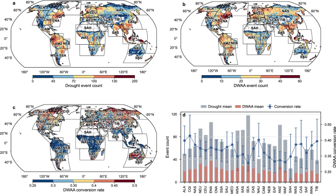
Rapid transitions from drought to extreme precipitation can trigger cascading impacts, but the influence of antecedent drought development on subsequent precipitation remains unclear. Dry–wet abrupt alternation events were identified using a global event-scale framework and separated into successive dry and wet phases. These events followed approximately 32% of droughts, and their frequency increased significantly in 58% of the 26 IPCC-SREX regions assessed in 1951-2020. Model-based analysis showed that drought-development characteristics contributed 25.7% of the predictive information distinguishing droughts with and without subsequent extreme precipitation. Rapid and intense soil-moisture decline was associated with earlier, more convective precipitation, particularly in mid- and high-latitude climate-transition regions, whereas prolonged and severe drought development was associated with delayed, more stratiform precipitation, especially in arid and tropical regions. Here, we show that antecedent drought development is linked to distinct, region-dependent pathways from drought to extreme precipitation, providing a basis for anticipating compound hydrological extremes. The study finds that nearly one-third of droughts worldwide are followed by extreme precipitation, with drought-development characteristics distinguishing distinct pathways to these dry–wet transitions.
Paleogeographic controls on Phanerozoic weathering rates and implications for climate regulation
Authors: R. J. Graham, B. B. Cael, M. Fu, D. S. Abbot
Journal: Nature Communications · DOI: 10.1038/s41467-026-77289-3
Matched topics: hydrology
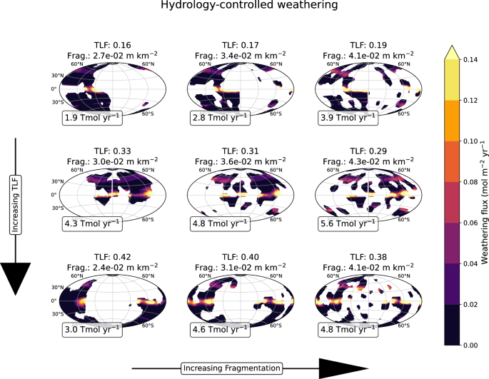
Earth’s climate has remained habitable for billions of years, a stability usually attributed to a negative feedback from silicate weathering – the chemical breakdown of silicate rocks on land, which consumes atmospheric carbon dioxide faster as climate warms. However, whether temperature or hydrology primarily drives this feedback remains uncertain. Here we show the two controls leave geographic fingerprints: in an ensemble of climate simulations with randomized continents, temperature-controlled weathering depends on tropical land fraction, whereas hydrology-controlled weathering depends on continental fragmentation. Stronger weathering removes more carbon dioxide, cooling the planet, so each regime predicts anti-correlation between temperature and its controlling geography. Reconstructed global temperatures spanning 480 million years are anti-correlated with tropical land fraction, except from roughly 295 to 200 million years ago – overlapping the supercontinent Pangea – when they anti-correlate with continental fragmentation. The mechanism stabilizing Earth’s climate may thus have evolved, with temperature control apparently dominant for most of this period.
Decision Calendars for Cold Regions Hydrological Forecasting: Collaboration in the Transboundary Yukon River Basin
Authors: David R. Casson, Andrea J. Ray, Anthony Bier, Holly Goulding, Dave Streubel, Johnse Ostman et al.
Journal: Bulletin of the American Meteorological Society · DOI: 10.1175/bams-d-25-0009.1
Matched topics: hydrology, river
Supporting decision making in hydrological forecasting depends on aligning scientific outputs with the practical needs and timelines of operational centers. This study documents the collaborative development of decision calendars with forecasters from the Alaska-Pacific River Forecast Center and the Yukon Government River Forecast Center in the transboundary, high-latitude Yukon River Basin, where hydrology is dominated by cold region processes. Decision calendars were used as a tool to synthesize shared operational knowledge, map recurring forecasting modes to an annual cycle, and identify critical timing for monitoring, forecasting and communication. The process highlighted challenges in transitioning research advances into operational practice, including reconciling data sources, communication needs, and the integration of new models and methods. Decision calendars inform the development of open-source forecasting workflows using the existing operational software framework. They also provide a basis for developing user-informed evaluation that assesses forecast performance based on operational needs. Findings emphasize the importance of knowledge sharing and structured methods to exchange information in developing actionable hydrological science. Lessons learned from the Yukon River Basin may be transferable to other regions seeking to improve forecast usability and uptake through structured collaboration between researchers and operational forecasters.
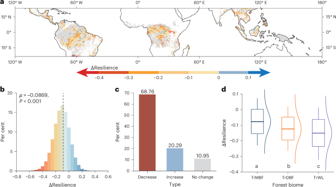
Precipitation and soil phosphorus regulate post-drought resilience in tropical forests
Authors: Yang Chu, Yuhao Feng, Yanjun Su, Chao Wu, Ying-Ping Wang, Tingting Li et al.
Journal: Nature Geoscience · DOI: 10.1038/s41561-026-02095-x
Matched topics: drought
Abstract not available.
AI for Science
How AI is changing research
- What science problem should AI tackle next? A new ‘challenge atlas’ offers answers (Science, 2026-09-10) — A new structured “challenge atlas” maps the hardest open problems in science where AI is expected to unlock breakthroughs — a practical navigation tool for researchers deciding where to invest AI-assisted effort next.
Cross-discipline sparks
- This road map could help us decide whether to deploy solar geoengineering (MIT Technology Review, 2026-09-10) — A new governance roadmap for stratospheric aerosol injection and marine cloud brightening is now live — and the hydrological implications are central. Solar geoengineering scenarios alter monsoon dynamics, regional precipitation, and drought/flood frequency in ways that land-surface and river-routing models can quantify. Small earth-science teams with existing ESM setups (e.g., E3SM or CESM) could run targeted hydrologic simulations under SAI scenarios, directly informing which geoengineering pathways are safest for freshwater systems — a tractable contribution that the governance community is actively asking for.
Statistics
| Metric | Count |
|---|---|
| Journals searched | 11 |
| Total papers fetched | 114 |
| Passed deterministic filter | 13 |
| After LLM relevance filtering | 6 |
| Rejected (not relevant) | 7 |
| AI for Science items picked | 2 |
Papers by journal
| Journal | Papers |
|---|---|
| Science | 1 |
| Geophysical Research Letters | 1 |
| Nature Communications | 2 |
| Nature Geoscience | 1 |
| Bulletin of the American Meteorological Society | 1 |
Filtering Criteria
Topics: hydrology, hydrologic model, river, runoff, streamflow, reservoir, water management, flood, drought, seasonal, land surface model, climate change, hydropower, surface water, irrigation, earth system model, estuary, coastal, freshwater discharge, river plume, ocean biogeochemistry, marine heatwave, paleohydrology, paleoclimate, Quaternary, Holocene, Pleistocene, fluvial geomorphology, river terrace, loess, drainage network, river capture, landscape evolution, luminescence dating
Fields: engineering, environmental science, computer science, geology, geography