Paper Harvest Report
Date range: October 28, 2026
4 top-tier papers selected out of 13 total publications
Today’s Highlights
A Nature Geoscience study using four decades of satellite data and explainable AI shows that vegetation stress is shifting from soil-moisture to vapour-pressure-deficit control — an asymmetric transition with large implications for land-surface model parameterization. A companion Nature paper maps Africa-wide water demand at high spatial resolution across six sectors, revealing that physical water availability alone does not explain water insecurity. A paleohydrology study in Nature demonstrates that Pleistocene human dispersal into the Arabian desert tracked the co-occurrence of freshwater and knappable stone, refining models of past river-basin habitability.
Table of Contents
Top-Tier Journal Papers
Vegetation increasingly controlled by atmospheric dryness rather than soil moisture
Authors: Lingcheng Li, Yilin Fang, Jiafu Mao, Shiqin Xu, Zhonghua Zheng, Wantong Li et al.
Journal: Nature Geoscience · DOI: 10.1038/s41561-026-02107-w
Matched topics: river, soil moisture, vapour pressure deficit, land surface, climate change
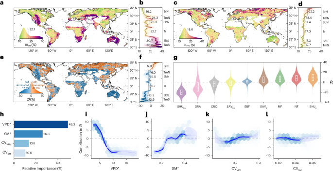
Terrestrial vegetation regulates global carbon cycling and climate through responses to water availability. Yet, it remains unclear whether soil moisture (SM) or atmospheric dryness (vapour pressure deficit, VPD) dominates vegetation responses and, more critically, how their relative influence changes over time, limiting predictions of ecosystem–climate feedback under warming. Here we analyse satellite-derived vegetation variability over the past four decades using an explainable artificial intelligence framework that disentangles nonlinear hydroclimatic driver contributions. We show SM dominates vegetation variability in most regions. However, VPD influence has strengthened while SM influence has weakened over time. These changes highlight an asymmetric transition with more SM-dominated ecosystems shifting towards increasing VPD control than vice versa. Changes in the mean and variability of SM and VPD drive this transition by altering plant water-stress responses. Continued warming will probably intensify this pattern as rising VPD and more frequent extreme events strengthen atmospheric constraints on vegetation.
Spatial and sectoral water demand assessment for the African continent
Authors: Davy Vanham, Dahami Gunathilake, Bhawani Gunasekara, Seifu Tilahun, Youssef Brouziyne, Fasikaw A. Zimale et al.
Journal: Nature · DOI: 10.1038/s41586-026-11199-8
Matched topics: river, hydropower, irrigation, water resources
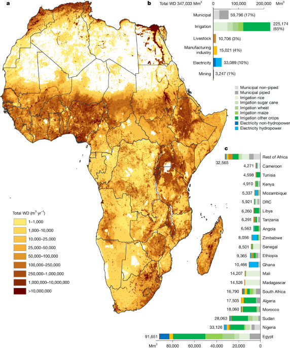
Water demand is the volume of water required by a sector to satisfy its needs. Across Africa, these demands are frequently unmet, yet their spatial and sectoral distribution remains incompletely characterized, limiting informed water-management decisions. Here, we provide an Africa-wide estimate of water demand for 2020 across six sectors and multiple subsectors at high spatial resolution. We estimate total annual water demand at 347 km³, comprising 60 km³ (17%) for municipalities, 225 km³ (65%) for irrigation, 11 km³ (3%) for livestock, 15 km³ (4%) for manufacturing, 33 km³ (10%) for electricity including hydropower and 3 km³ (1%) for mining. Estimated demand increased by 26% between 2010 and 2020. The dominant water-demand sector varies across regions and river basins, broadly reflecting established geographical and socioeconomic patterns. In parts of northern and southern Africa, estimated demand exceeds water availability, although results depend on assumptions regarding environmental-flow protection. Elsewhere, water availability exceeds aggregate demand despite limited access to piped drinking water, indicating that physical availability alone does not determine water security.
Stone and water governed early human settlement of the desert
Authors: Rudolf W. Dellmour, Emily Coco, Osama Samawi, Mohammed Al Kindi, Ali Al Mahrooqi, Michelle R. Bebber et al.
Journal: Nature · DOI: 10.1038/s41586-026-11180-5
Matched topics: Pleistocene, paleohydrology, freshwater, desert dispersal
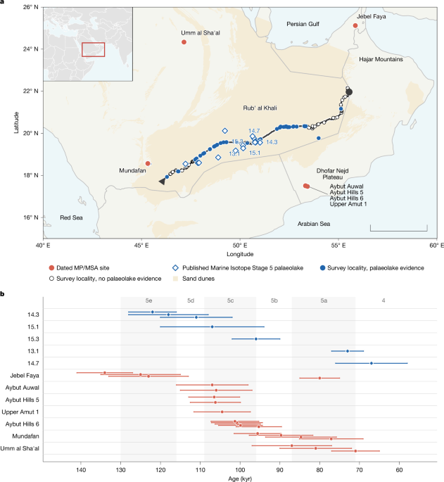
Models of early human dispersal rely on climate to predict where populations could settle, with freshwater assumed to govern the timing and geography, particularly across the Saharo-Arabian arid belt, where humid windows episodically opened corridors into the desert interior. Yet Pleistocene dispersals into ‘Green Arabia’ were brief and geographically constrained, a pattern not explained by water availability alone. Here we show, from an approximately 1,500-km geoarchaeological survey through the Rub’ al Khali of Arabia, the largest sand sea in the world, that the availability of stone for tool manufacture operated as an independent factor on early human settlement. Palaeolake deposits were recorded at 55 of 125 localities investigated, yet no lithic artefacts and no knappable raw materials were found along the transect, with ground-surface visibility exceeding 95%, despite abundant freshwater and contemporary occupation at the desert margins. Spatial modelling of the Peninsula supports the inference that settlement tracked the co-occurrence of water and lithic raw materials rather than water alone. Dispersal models that omit raw-material geology may systematically overestimate the habitable range of stone-tool-dependent populations.
Air pollution amplifies the humid heat anomalies in India
Authors: Junyan Chen, Siyu Chen, Khan Alam, Dan Tong, Salman Zare, Xinyang Guo et al.
Journal: Bulletin of the American Meteorological Society · DOI: 10.1175/bams-d-25-0097.1
Matched topics: climate change, soil moisture, land surface, aerosol-hydrology coupling

India is confronting intensifying humid heat coupled with severe air pollution. While air pollution is known to reduce near-surface temperatures, its non-linear impact on humid heat remains insufficiently understood, limiting our comprehension of current warming conditions and future projections for India. Here, using observations, reanalysis data, and model simulations, we demonstrate how air pollution affects humid heat and project its future evolution under climate change. Our results indicate that air pollution generally mitigates dry heat conditions, however, it exacerbates humid heat anomalies on approximately one-fifth of days. Absorbing aerosols warm the atmosphere, induce a heat dome effect, elevate surface sensible heat flux, and reduce soil moisture. This process strengthens soil moisture–atmosphere coupling, ultimately amplifying humid heat anomalies. Projections under different future scenarios indicate a prospective increase in humid heat over India, with the most prominent changes expected in the densely populated Ganges Plain.
AI for Science
How AI is changing research
- AI agents run this automated biology lab that sequences DNA and more (Nature, 2026-11-05) — An AI-native laboratory system (described in a companion Nature paper) autonomously directs robotic instruments, plans experiments, sequences DNA, and interprets results in a closed loop — with minimal human intervention. This represents a qualitative shift from AI-assisted science to AI-driven science, where the agent sets the experimental agenda. Earth-science labs running routine isotope analysis, water-quality sensing, or sediment characterisation could adopt the same agentic architecture: an agent that monitors sensor outputs, decides what to measure next, and flags anomalies — letting a small team scale up observational throughput without proportional headcount growth.
Statistics
| Metric | Count |
|---|---|
| Journals searched | 11 |
| Total papers fetched | 96 |
| Passed deterministic filter | 13 |
| After LLM relevance filtering | 4 |
| Rejected (not relevant) | 9 |
| AI for Science items picked | 1 |
Papers by journal
| Journal | Papers |
|---|---|
| Nature | 2 |
| Nature Geoscience | 1 |
| Bulletin of the American Meteorological Society | 1 |
Filtering Criteria
Topics: river, streamflow, flood, drought, reservoir, hydropower, irrigation, water management, water resources, runoff, groundwater, watershed, basin, precipitation, evapotranspiration, soil moisture, land surface, earth system model, climate change, remote sensing, machine learning, hydrologic, hydraulic, coastal, estuary, ocean, Pleistocene, Holocene, paleohydrology, geomorphology, fluvial, loess, luminescence, OSL, paleoclimate, Quaternary, seasonal, surface water
Fields: Hydrology, Environmental Science, Geography, Earth and Planetary Sciences, Oceanography, Geology, Atmospheric Science